Medina County, Ohio
| Medina County, Ohio | ||
|---|---|---|

Medina County Courthouse
|
||
|
||
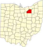
 Location in the U.S. state of Ohio |
||
 Ohio's location in the U.S. |
||
| Founded | 1812 | |
| Named for | Medina | |
| Seat | Medina | |
| Largest city | Brunswick | |
| Area | ||
| • Total | 423 sq mi (1,096 km2) | |
| • Land | 421 sq mi (1,090 km2) | |
| • Water | 1.7 sq mi (4 km2), 0.4% | |
| Population | ||
| • (2010) | 172,332 | |
| • Density | 409/sq mi (158/km²) | |
| Congressional districts | 7th, 16th | |
| Time zone | Eastern: UTC-5/-4 | |
| Website | www |
|
Medina County (pronounced /məˈdaɪnə/) is a county in the U.S. state of Ohio. As of the 2010 census, the population was 172,332. Its county seat is Medina. The county was created in 1812 and later organized in 1818. It is named for Medina, though the "I" in it is pronounced as in "dine."
Medina County is part of the Cleveland-Elyria, OH Metropolitan Statistical Area, although some sections have closer ties to the Akron area.
After the discovery of the New World, the land that became Medina County was originally part of the French colony of Canada (New France), which was ceded in 1763 to Great Britain and renamed Province of Quebec. In the late 18th century the land became part of the Connecticut Western Reserve in the Northwest Territory, then was purchased by the Connecticut Land Company in 1795. Parts of Medina County and neighbouring Lorain became home to the The Black River Colony founded in 1852, a religious community centered on the pious lifestyle of the German Baptist Brethren.
...
Wikipedia

