Meadowbrook Middle School
| Poway | |||
|---|---|---|---|
| General law city | |||
| City of Poway | |||

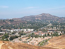
The Twin Peaks above Poway in August 2004.
|
|||
|
|||
| Motto: "The City in the Country!" | |||
 Location in San Diego County |
|||
| Location in the United States | |||
| Coordinates: 32°58′12″N 117°02′19″W / 32.97000°N 117.03861°WCoordinates: 32°58′12″N 117°02′19″W / 32.97000°N 117.03861°W | |||
| Country | United States | ||
| State | California | ||
| County | San Diego | ||
| Incorporated | 12 December 1980 | ||
| Government | |||
| • Type | Council-Manager | ||
| • Body |
|
||
| • City manager | Dan Singer | ||
| Area | |||
| • Total | 39.16 sq mi (101.44 km2) | ||
| • Land | 39.08 sq mi (101.21 km2) | ||
| • Water | 0.09 sq mi (0.22 km2) 0.22% | ||
| Elevation | 515 ft (157 m) | ||
| Population (2010) | |||
| • Total | 47,811 | ||
| • Estimate (2016) | 50,077 | ||
| • Density | 1,281.43/sq mi (494.76/km2) | ||
| Demonym(s) | Powegian | ||
| Time zone | PST (UTC-08:00) | ||
| • Summer (DST) | PDT (UTC-07:00) | ||
| ZIP codes | 92064, 92074 | ||
| Area code | 858 | ||
| FIPS code | 06-58520 | ||
| GNIS feature IDs | 1661258, 2411480 | ||
| Website | www |
||
Poway /ˈpaʊ.eɪ/ is a city in San Diego County, California. Originally an unincorporated community in the county, Poway officially became a city on December 12, 1980. Poway's rural roots gave rise to its slogan "The City in the Country". As of the 2010 census, the city had a population of 47,811. The ZIP code is 92064.
Poway is located at 32°58′12″N 117°2′19″W / 32.97000°N 117.03861°W (32.969895, −117.038479), which lies north of the city of San Diego and south of the city of Escondido. Some nearby communities are Rancho Bernardo, Sabre Springs, Scripps Ranch, Rancho Peñasquitos, and Ramona to the East. According to the United States Census Bureau, the city has a total area of 39.3 square miles (102 km2), of which 0.1 square miles (0.26 km2) (0.25%) is water.
...
Wikipedia


