Rancho Peñasquitos, San Diego
| Rancho Peñasquitos, San Diego | |
|---|---|
| Community of San Diego | |
| Rancho Peñasquitos | |
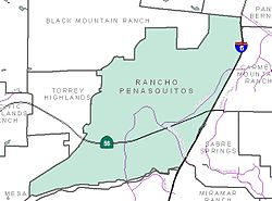
 Rancho Peñasquitos and neighborhood boundaries |
|
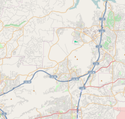
| Location within Northeastern San Diego | |
| Coordinates: 32°57′34″N 117°06′56″W / 32.9594°N 117.115575°W | |
| Country | |
| State |
|
| County |
|
| City |
|
| Website | Official website |
Coordinates: 32°57′33.84″N 117°06′56.07″W / 32.9594000°N 117.1155750°W
Rancho Peñasquitos is a suburban community in the northeastern part of the city of San Diego, California. It is named after the first Mexican land grant in the county, Rancho Santa Maria de Los Peñasquitos. Peñasquitos means "little cliffs" in Spanish. It abuts Los Peñasquitos Canyon Preserve, an open space preserve that offers hiking, biking, and equestrian trails. The community is commonly abbreviated "PQ."
The population of PQ is approximately 60,000. it is located in ZIP code 92129. The telephone area code is 858.
Rancho Peñasquitos is roughly bounded:
The highest point in the community is Black Mountain, which rises to an elevation of 1,500 feet (460 m).
Native American Kumeyaay history within the area dates back as far as 7,000 years ago. Remains of the prehistoric culture can still be found. Rancho de los Peñasquitos was present-day San Diego County's first rancho, the Rancho Santa Maria de Los Peñasquitos. In 1823, one league (4,243 acres; 17 km²) was awarded to Captain Francisco María Ruiz, a Commandant of the Presidio of San Diego. This one league was at the eastern part of the Los Peñasquitos Canyon and extended into Sabre Springs and up to Rancho Bernardo.
...
Wikipedia

