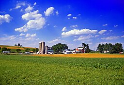
Maxatawny Township, Pennsylvania
| Maxatawny Township | |
| Township | |
|
A farm in Maxatawny Township
|
|
| Country | United States |
|---|---|
| State | Pennsylvania |
| County | Berks |
| Elevation | 423 ft (128.9 m) |
| Coordinates | 40°29′30″N 75°44′29″W / 40.49167°N 75.74139°WCoordinates: 40°29′30″N 75°44′29″W / 40.49167°N 75.74139°W |
| Area | 26.3 sq mi (68.1 km2) |
| - land | 26.2 sq mi (68 km2) |
| - water | 0.04 sq mi (0 km2), 0.15% |
| Population | 7,906 (2010) |
| Density | 228.0/sq mi (88.0/km2) |
| Founded | 1732 |
| Timezone | EST (UTC-5) |
| - summer (DST) | EDT (UTC-4) |
| Area code | 610 |
|
Website: www |
|
Maxatawny Township is a township in Berks County, Pennsylvania, United States. The population was 7,906 at the 2010 census.
Maxatawny is a name derived from a Native American language purported to mean "bear's path creek".
The Boyer-Mertz Farm, Hottenstein Mansion, Kemp's Hotel, and Siegfried's Dale Farm are listed on the National Register of Historic Places.
According to the United States Census Bureau, the township has a total area of 26.3 square miles (68.0 km²). 26.2 square miles (68.0 km²) of it is land and 0.04 square miles (0.1 km²) of it (0.15%) is water. Its villages include Bowers, Hinterleiter, Maxatawny, Mill Creek Corner, and Monterey. The township is in the Delaware River watershed and most of it is drained by the Sacony Creek into the Schuylkill River. An area in the eastern portion is drained by the Little Lehigh Creek into the Lehigh River.
Adjacent townships
Maxatawny Township surrounds the borough of Kutztown, and touches Lyons to the south and Topton to the east.
As of the census of 2000, there were 5,982 people, 1,348 households, and 997 families residing in the township. The population density was 228.0 people per square mile (88.0/km²). There were 1,384 housing units at an average density of 52.8/sq mi (20.4/km²). The racial makeup of the township was 96.05% White, 1.99% African American, 0.08% Native American, 0.60% Asian, 0.13% Pacific Islander, 0.33% from other races, and 0.80% from two or more races. Hispanic or Latino of any race were 1.45% of the population.
...
Wikipedia


