Schuylkill River
| Schuylkill River | |
| River | |
|
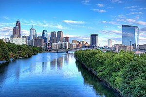
The Schuylkill River looking south toward the Philadelphia skyline
|
|
| Name origin: "hidden/skulking creek" in Dutch | |
| Country | United States |
|---|---|
| State | Pennsylvania |
| Counties | Philadelphia, Montgomery, Chester, Berks, Schuylkill |
| Tributaries | |
| - left | Little Schuylkill River, Perkiomen Creek |
| - right | Tulpehocken Creek, French Creek |
| Cities | Philadelphia, Norristown, Pottstown, Reading |
| Source | East Branch Schuylkill River |
| - location | Tuscarora, Schuylkill County, Pennsylvania, United States |
| - elevation | 1,540 ft (469 m) |
| - coordinates | 40°46′24″N 76°01′20″W / 40.77333°N 76.02222°W |
| Secondary source | West Branch Schuylkill River |
| - location | Minersville, Schuylkill County, Pennsylvania, United States |
| - elevation | 1,140 ft (347 m) |
| - coordinates | 40°42′51″N 76°18′46″W / 40.71417°N 76.31278°W |
| Source confluence | |
| - location | Schuylkill Haven, Schuylkill County, Pennsylvania, United States |
| - elevation | 520 ft (158 m) |
| - coordinates | 40°38′01″N 76°10′49″W / 40.63361°N 76.18028°W |
| Mouth | Delaware River |
| - location | Philadelphia, Pennsylvania, United States |
| - elevation | 0 ft (0 m) |
| - coordinates | 39°53′04″N 75°11′41″W / 39.88444°N 75.19472°WCoordinates: 39°53′04″N 75°11′41″W / 39.88444°N 75.19472°W |
| Length | 135 mi (217 km) |
| Basin | 2,000 sq mi (5,180 km2) |
| Discharge | for Philadelphia |
| - average | 4,650 cu ft/s (132 m3/s) |
| - max | 40,300 cu ft/s (1,141 m3/s) |
| - min | 995 cu ft/s (28 m3/s) |
| Discharge elsewhere (average) | |
| - Berne | 1,120 cu ft/s (32 m3/s) |
|
The river's watershed drains parts of the Pocono Mountains and the Pennsylvania Coal Region
|
|
The Schuylkill River (/ˈskuːlkɪl/ SKOOL-kil, locally /ˈskuːkəl/ SKOO-kəl) is an important river in central and eastern Pennsylvania. Two of its tributaries drain parts of the Pocono Mountains in the east and Coal Region in the center of the state. It flows for 135 miles (217 km) before joining the Delaware River as its largest tributary, in Philadelphia.
In 1682 William Penn chose one bank of the confluence upon which he founded the planned city of Philadelphia on lands purchased from the native Delaware nation. It is a designated Pennsylvania Scenic River, and its whole length was once part of the Delaware people's southern territories. Its upper end rises in what are called the richest anthracite coal fields in the world.
...
Wikipedia


