Lyons, Pennsylvania
| Lyons, Pennsylvania | |
| Lyon Station | |
| Borough | |
|
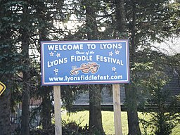
Lyons welcome sign
|
|
| Country | United States |
|---|---|
| State | Pennsylvania |
| County | Berks |
| Elevation | 476 ft (145.1 m) |
| Coordinates | 40°28′49″N 75°45′25″W / 40.48028°N 75.75694°WCoordinates: 40°28′49″N 75°45′25″W / 40.48028°N 75.75694°W |
| Area | 0.9 km2 (0.3 sq mi) |
| - land | 0.9 km2 (0 sq mi) |
| - water | 0.0 km2 (0 sq mi) |
| Population | 478 (2010) |
| Density | 518.8/km2 (1,343.7/sq mi) |
| Timezone | EST (UTC-5) |
| - summer (DST) | EDT (UTC-4) |
| ZIP code | 19536 |
| Area code | 610 and 484 |
|
Website: www |
|
Lyons (also known as Lyon Station) is a borough in Berks County, Pennsylvania, United States. The population was 478 at the 2010 census.
Lyons was founded as Lyon Station in 1860 when the railroad was extended to that point. The community was named for Charles Lyons, a railroad official.
On May 31, 1998, an F3 tornado touched down in Lyons causing roughly $1,400,000 worth of damage to local homes and properties. The town was closed off for nearly a month to all non-residents save for construction teams and the Red Cross.
Lyons is located in eastern Berks County at 40°28′49″N 75°45′25″W / 40.48028°N 75.75694°W (40.480194, -75.756987). It is bordered by Maxatawny Township on its north, east, and south sides, and by Richmond Township to the southwest. The unincorporated community of Bowers borders the east side of Lyons.
Lyons is located 3 miles (5 km) south of Kutztown. Topton is 3 miles (5 km) to the east, and Fleetwood is 4 miles (6 km) to the west.
According to the United States Census Bureau, Lyons has a total area of 0.35 square miles (0.9 km2), all of it land.
...
Wikipedia


