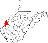
Mason County, West Virginia
| Mason County, West Virginia | |
|---|---|
 Location in the U.S. state of West Virginia |
|
 West Virginia's location in the U.S. |
|
| Founded | January 2, 1804 |
| Seat | Point Pleasant |
| Largest city | Point Pleasant |
| Area | |
| • Total | 445 sq mi (1,153 km2) |
| • Land | 431 sq mi (1,116 km2) |
| • Water | 14 sq mi (36 km2), 3.1% |
| Population (est.) | |
| • (2015) | 27,037 |
| • Density | 63/sq mi (24/km²) |
| Congressional district | 3rd |
| Time zone | Eastern: UTC-5/-4 |
| Website | www |
Mason County is a county in the U.S. state of West Virginia. As of the 2010 census, the population was 27,324. Its county seat is Point Pleasant. The county was founded in 1804 and named for George Mason, delegate to the U.S. Constitutional Convention. Before the Civil War, the county was in the State of Virginia.
Mason County is part of the Point Pleasant, WV-OH Micropolitan Statistical Area.
In the second half of 1749, the French explorer, Pierre Joseph Céloron de Blainville, claimed French sovereignty over the Ohio Valley, burying a lead plaque at the meeting point of the Ohio and Kanawha Rivers, naming the place Point Pleasant.
In the Battle of Point Pleasant (October 10, 1774), fought on the future site of the town, over one thousand Virginia militiamen, led by Colonel Andrew Lewis (1720–1781), defeated a roughly equal force of an Algonquin confederation of Shawnee and Mingo warriors led by Shawnee Chief Cornstalk (ca. 1720-1777). The event is celebrated locally as the "First Battle of the American Revolutionary War" and in 1908 the U.S. Senate authorized erection of a local monument to commemorate it as such. Most historians, however, regard it not as a battle of the Revolution (1775–1783), but as a part of Lord Dunmore's War (1774). "Camp Point Pleasant" was established by Col. Lewis at the time of the Battle and the settlement that followed also took that name. Although not certain, Point Pleasant may have been permanently settled by whites as early as 1774.
...
Wikipedia
