Mardin
| Mardin | |
|---|---|
| Metropolitan municipality | |

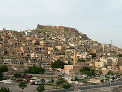
The old city of Mardin
|
|
| Location of Mardin within Turkey. | |
| Coordinates: 37°19′0″N 40°44′16″E / 37.31667°N 40.73778°ECoordinates: 37°19′0″N 40°44′16″E / 37.31667°N 40.73778°E | |
| Country |
|
| Region | Southeastern Anatolia |
| Province | Mardin |
| Government | |
| • Mayor | Ahmet Türk |
| • Co-Mayor | Februniye Akyol |
| Area | |
| • District | 969.06 km2 (374.16 sq mi) |
| Elevation | 1,083 m (3,553 ft) |
| Population (2012) | |
| • Urban | 86,948 |
| • District | 139,254 |
| • District density | 140/km2 (370/sq mi) |
| Time zone | FET (UTC+3) |
| Postal code | 47x xx |
| Area code(s) | 0482 |
| Vehicle registration | 47 |
| Website |
www www www |
Mardin (Kurdish: Mêrdîn, Syriac: ܡܶܪܕܺܝܢ, Arabic/Ottoman Turkish: ماردين Mārdīn) is a city in southeastern Turkey. The capital of Mardin Province, it is known for the Artuqid (Artıklı or Artuklu in Turkish) architecture of its old city, and for its strategic location on a rocky hill near the Tigris River that rises steeply over the flat plains.
The territory of Mardin and Karaca Dağ was known as Izalla in the Late Bronze Age (variously: KURAzalzi, KURAzalli, KURIzalla), an originally Hurrian kingdom.
The city and its surrounds were absorbed into Assyria proper during the Middle Assyrian Empire (1365-1020 BC), and then again during the Neo Assyrian Empire (911-605 BC).
The ancient name was rendered as Izalā in Old Persian, and during the Achaemenid Empire (546-332 BCE) according to the Behistun Inscription it was still regarded as a part of the geo-political entity of Assyria (Achaemenid Assyria, Athura).
It survived into the Assyrian Christian period as the name of Mt. Izala (Izla), on which in the early 4th century AD stood the monastery of Nisibis, housing seventy monks.
...
Wikipedia

