Mara Rosa
| Mara Rosa | |
|---|---|
| Municipality | |
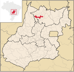
 Location in Goiás state |
|
| Location in Brazil | |
| Coordinates: 14°01′02″S 49°10′35″W / 14.01722°S 49.17639°WCoordinates: 14°01′02″S 49°10′35″W / 14.01722°S 49.17639°W | |
| Country |
|
| Region | Central-West Region |
| State | Goiás |
| Microregion | Porangatu Microregion |
| Area | |
| • Total | 1,704 km2 (658 sq mi) |
| Elevation | 530 m (1,740 ft) |
| Population (2007) | |
| • Total | 10,409 |
| • Density | 6.1/km2 (16/sq mi) |
| Time zone | BRT/BRST (UTC-3/-2) |
| Postal code | 76490-000 |
Mara Rosa is a municipality in north-central Goiás state, Brazil.
Mara Rosa is located 356 kilometers north of Goiânia in the Porangatu Microregion. It is 11 kilometers east of the Belém-Brasília highway, between the basins of the Araguaia River and the . Neighboring municipalities are: Alto Horizonte, Amaralina, Campinorte, Campos Verdes de Goiás, Estrela do Norte, Formoso, Mutunópolis, Nova Iguaçu de Goiás, Santa Terezinha de Goiás, and Uirapuru.
Highway communications with Goiânia are made by GO-080 / Nerópolis / São Francisco de Goiás / BR-153 / Jaraguá / GO-080 / Goianésia / Barro Alto / GO-342 / BR-153 / Uruaçu / Campinorte / GO-239.
Mara Rosa is considered one of the oldest municipalities in the state. The discovery of gold took many people to the region. The first houses appeared in 1742, 15 years after the founding of Vila Boa, the former capital of the state. The first name was Amaro Leite, a tribute to its founder, Amaro Leite Moreira. The district of Amaro Leite belonged to the Comarca de Pilar in 1911. In 1933 it was a district of Santana de Uruaçu. In 1953 it separated from Uruaçu to become the city of Amaro Leite. This settlement was transferred to another site and in 1960 the name was changed to Mara Rosa as a tribute to José Maurício de Moura.
...
Wikipedia

