Goiânia
| Municipality of Goiânia | |||
|---|---|---|---|
| Municipality | |||

Top left:Vaca Brava Park and St Bueno area, Top right:Memorial site of Goiânia Train Station in Estacao Park, 2nd left:Monument of Tres Marcos in Latif Sebba Square, 2nd right:Night view of Joao Alaves Queiroz Viaduct, 3rd left:Goiânia Botanical Garden, 3rd right:Monument of Tres Racas in Goiânia Civic Square, Bottom:Night view of downtown Goiânia
|
|||
|
|||
| Nickname(s): Capital do Cerrado (Capital of the Cerrado) | |||
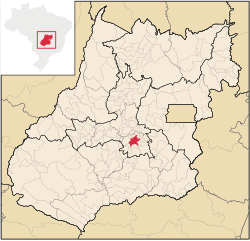
 Location of Goiânia |
|||
| Location in Brazil | |||
| Coordinates: 16°40′S 49°15′W / 16.667°S 49.250°WCoordinates: 16°40′S 49°15′W / 16.667°S 49.250°W | |||
| Country |
|
||
| Region | Central-West | ||
| State |
|
||
| Founded | October 24, 1933 | ||
| Government | |||
| • Mayor | Paulo de Siqueira Garcia (PT) | ||
| Area | |||
| • Municipality | 789 km2 (305 sq mi) | ||
| • Metro | 739 km2 (285 sq mi) | ||
| Elevation | 749 m (2,457 ft) | ||
| Population (2016) | |||
| • Municipality | 1,448,639 (12th) | ||
| • Density | 1,604/km2 (4,150/sq mi) | ||
| • Metro | 2,458,504 (10th) | ||
| Time zone | UTC-3 (UTC-3) | ||
| • Summer (DST) | UTC-2 (UTC-2) | ||
| Postal Code | 74000-000 | ||
| Area code(s) | +55 62 | ||
| Demonym | goianiense | ||
| Website | www.goiania.go.gov.br | ||
Goiânia (/ɡɔɪˈɑːniə/;Portuguese pronunciation: [ɡojˈjɐniɐ]) is the capital and largest city of the Brazilian state of Goiás. With a population of 1,301,892, it is the second-largest city in the Central-Western Region and the 13th-largest in the country. Its metropolitan area has a population of 2,063,744, making it the 11th-largest in Brazil. With an area of approximately 739 km2 (285 sq mi), it has a continuous geography, with few hills and lowlands, with flat lands in most of its territory, especially the Meia Ponte River, in addition to Botafogo and Capim Puba streams.
Goiânia is a planned city founded on October 24, 1933 by then Governor Pedro Ludovico to serve as the new state capital and administrative center. Before this, the state capital was the town of Goiás.
It is the second most populous city in Brazil's Midwest, only surpassed by the country's capital Brasília. It is an important economic hub of the region, and is considered a strategic center for such areas as industry, medicine, fashion and agriculture. Goiânia has the largest green area per inhabitant in Brazil and the second-most in the world, after Edmonton, Canada.
The idea of creating a new state capital had been bounced around from early on in the state of Goiás. The first plan came from D. Marcos de Noronha who in 1753 wanted to establish the state capital in the municipality of Pirenópolis; again in 1863 José Vieira Couto de Magalhães put forward a plan to move the capital to the edge of the river Araguaia.
...
Wikipedia


