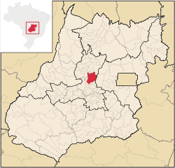
Jaraguá, Goiás
| Jaraguá | |
|---|---|
| Municipality | |
 Location in Goiás state |
|
| Location in Brazil | |
| Coordinates: 15°44′23″S 49°20′05″W / 15.73972°S 49.33472°WCoordinates: 15°44′23″S 49°20′05″W / 15.73972°S 49.33472°W | |
| Country |
|
| Region | Central-West Region |
| State | Goiás |
| Microregion | Anápolis Microregion |
| Area | |
| • Total | 1,888.9 km2 (729.3 sq mi) |
| Elevation | 666 m (2,185 ft) |
| Population (2015) | |
| • Total | 46,790 |
| • Density | 25/km2 (64/sq mi) |
| Time zone | BRT/BRST (UTC-3/-2) |
| Postal code | 76330-000 |
Jaraguá is a municipality in central Goiás state, Brazil. It is a regional center and a producer of agricultural products, clothing, and cattle.
Considered to be the national capital of the clothing industry, Jaraguá is in the Vale do São Patrício on the important Belém-Brasília highway (BR-153). It is 124 km from the state capital of Goiânia and 230 km from the federal capital of Brasília. Anápolis, the second largest city in the state of Goiás, lies 90 km to the south.
Highway connections from Goiânia are made by GO-080 / Nerópolis / São Francisco de Goiás / BR-153 /. For a complete list of distances and highway connections in the state of Goiás see Seplan
Goianésia, Itaguari, Itaguaru, Jesúpolis, Pirenópolis, Rianápolis, Santa Isabel, Santa Rosa de Goiás, São Francisco de Goiás, Taquaral de Goiás and Uruana.
Today Jaraguá has a solid economy based on agriculture, cattle raising and the clothing industry. In agriculture Jaraguá produces pineapple, watermelon, corn, rice, and beans. In cattle raising it has one of the largest herds of cattle in the state (176,000 in 2007) and is a leader in milk and dairy product production with 32,000 milking cows. Jaraguá is the largest producer of pineapple in the state of Goiás, with most of the product being exported to São Paulo.
...
Wikipedia

