Manville, New Jersey
| Manville, New Jersey | |
|---|---|
| Borough | |
| Borough of Manville | |

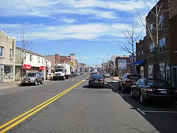
Central business district of Manville
|
|
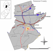
 Map of Manville in Somerset County. Inset: Location of Somerset County highlighted in the State of New Jersey. |
|
 Census Bureau map of Manville, New Jersey |
|
| Coordinates: 40°32′29″N 74°35′21″W / 40.54127°N 74.589273°WCoordinates: 40°32′29″N 74°35′21″W / 40.54127°N 74.589273°W | |
| Country |
|
| State |
|
| County | Somerset |
| Incorporated | April 18, 1929 |
| Government | |
| • Type | Borough |
| • Body | Borough Council |
| • Mayor | Richard Onderko (R, term ends December 31, 2019) |
| • Administrator | Andrea L. Bierwirth |
| • Clerk | Patricia Zamorski |
| Area | |
| • Total | 2.449 sq mi (6.342 km2) |
| • Land | 2.361 sq mi (6.114 km2) |
| • Water | 0.088 sq mi (0.228 km2) 3.60% |
| Area rank | 376th of 566 in state 15th of 21 in county |
| Elevation | 56 ft (17 m) |
| Population (2010 Census) | |
| • Total | 10,344 |
| • Estimate (2015) | 10,429 |
| • Rank | 237th of 566 in state 11th of 21 in county |
| • Density | 4,382.0/sq mi (1,691.9/km2) |
| • Density rank | 134th of 566 in state 5th of 21 in county |
| Time zone | Eastern (EST) (UTC-5) |
| • Summer (DST) | Eastern (EDT) (UTC-4) |
| ZIP code | 08835 |
| Area code(s) | 908 |
| FIPS code | 3403543620 |
| GNIS feature ID | 0885291 |
| Website | Official website |
Manville is a borough in Somerset County, New Jersey, United States. As of the 2010 United States Census, the borough's population was 10,344, reflecting an increase of one person (+0.0%) from the 10,343 counted in the 2000 Census, which had in turn declined by 224 (-2.1%) from the 10,567 counted in the 1990 Census. Manville was named after the Johns-Manville Corporation, which maintained a large manufacturing facility in the borough for decades.
Historically, many of Manville's residents are of Slavic — mostly eastern Polish (23.1% of the borough's population in 2000) and western Ukrainian descent — with many businesses and restaurants geared towards the Polish-American community located along Main Street (County Route 533).
Manville was formed by an act of the New Jersey Legislature on April 1, 1929, subject to the results of a referendum held on April 18, 1929.
According to the United States Census Bureau, the borough had a total area of 2.449 square miles (6.342 km2), including 2.361 square miles (6.114 km2) of land and 0.088 square miles (0.228 km2) of water (3.60%).
Unincorporated communities, localities and place names located partially or completely within the borough include Millsboro.
The borough borders Bridgewater Township, Franklin Township and Hillsborough Township.
Much of Manville is in a low-lying flood plain and is surrounded by rivers and streams on all but the western side which borders neighboring Hillsborough Township by land. The Raritan River forms the northern boundary of the borough and is met by the Millstone River which forms the eastern boundary of the borough, where a weir exists at the confluence of the rivers which is used for water intake purposes by New Jersey American Water.
...
Wikipedia
