Mantua, Ohio
| Mantua, Ohio | |
|---|---|
| Village | |

Businesses in the Mantua Station Brick Commercial District
|
|
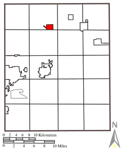
 Location of Mantua, Ohio |
|
 Location within Portage County |
|
| Coordinates: 41°17′1″N 81°13′23″W / 41.28361°N 81.22306°WCoordinates: 41°17′1″N 81°13′23″W / 41.28361°N 81.22306°W | |
| Country | United States |
| State | Ohio |
| County | Portage |
| Area | |
| • Total | 1.42 sq mi (3.68 km2) |
| • Land | 1.40 sq mi (3.63 km2) |
| • Water | 0.02 sq mi (0.05 km2) |
| Elevation | 1,148 ft (350 m) |
| Population (2010) | |
| • Total | 1,043 |
| • Estimate (2012) | 1,033 |
| • Density | 745.0/sq mi (287.6/km2) |
| Time zone | Eastern (EST) (UTC-5) |
| • Summer (DST) | EDT (UTC-4) |
| ZIP code | 44255 |
| Area code(s) | 330 |
| FIPS code | 39-47180 |
| GNIS feature ID | 1061147 |
Mantua (/ˈmænəweɪ/ MAN-ə-way) is a village in Portage County, Ohio, United States. It was formed from portions of Mantua Township in the Connecticut Western Reserve. The population was 1,043 at the 2010 census. It is part of the Akron Metropolitan Statistical Area.
The first settlers came to Mantua Township in 1798. The area that eventually became the village of Mantua was laid out in the 1840s as Mantua Station, a stop on the Cleveland and Mahoning Valley Railroad. It was incorporated as Mantua in 1898. Like the township, the village is named after the Italian city of Mantua in honor of Napoleon, who had captured Mantua in early 1797 at the end of the Siege of Mantua.
Mantua includes three properties on the National Register of Historic Places: the Horace L. Hine House, the Mantua Station Brick Commercial District, and the William H. Crafts House.
According to the United States Census Bureau, the village has a total area of 1.42 square miles (3.68 km2), of which 1.40 square miles (3.63 km2) is land and 0.02 square miles (0.05 km2) is water. The Cuyahoga River flows through the southern part of the village.
...
Wikipedia
