Malelane
|
Malalane (formerly Malelane) |
|
|---|---|

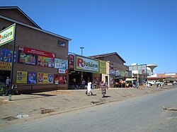
A street in Malalane
|
|
|
|
|
| Coordinates: 25°29′S 31°31′E / 25.483°S 31.517°ECoordinates: 25°29′S 31°31′E / 25.483°S 31.517°E | |
| Country | South Africa |
| Province | Mpumalanga |
| District | Ehlanzeni |
| Municipality | Nkomazi |
| Government | |
| • Type | Part of a Local municipality |
| Area | |
| • Total | 2.94 km2 (1.14 sq mi) |
| Population (2011) | |
| • Total | 3,486 |
| • Density | 1,200/km2 (3,100/sq mi) |
| Racial makeup (2011) | |
| • Black African | 43.2% |
| • Coloured | 2.6% |
| • Indian/Asian | 10.7% |
| • White | 43.2% |
| • Other | 0.3% |
| First languages (2011) | |
| • Afrikaans | 41.2% |
| • Swazi | 25.6% |
| • English | 17.9% |
| • Tsonga | 3.4% |
| • Other | 11.8% |
| Time zone | SAST (UTC+2) |
| Postal code (street) | 1320 |
| PO box | 1320 |
| Area code | 013 |
Malalane (formerly Malelane) is a farming town in Mpumalanga, South Africa situated on the N4 national highway. The farms in the region produce sugarcane, subtropical fruit and winter vegetables. The town was proclaimed in 1949 after which it was named. The origin of the name is disputed but was corrupted from the swazi. Either the expression "eMlalani" which means place of the palms, or the expression "lala" which means to sleep are accepted origins of the name. The town started as the first rest-stop between Lourenço Marques and Pretoria. As of July 2007 the town was officially renamed from "Malelane" to "Malalane" as part of the governments renaming scheme by the South African Geographical Names Council. This peculiar move by the government has been costly to numerous businesses and was met with some confusion as many thought that the name was already a native word.
One of Malelane's earliest pioneers was Captain GJ (Mkonto) Elphick. After having fought in the Anglo-Boer War (1899-1902), Elphick bought the old Malelane farm and successfully planted tomatoes, cotton, mangos, oranges and pawpaws. Elphick also pioneered the commercial aspect of Malelane by opening the first store in the vicinity.
Despite Elphick's operations, the Onderberg area was predominantly a bush area and formed part of The Kruger Shooting Concession. Leopard, lion and buffalo were often shot as a sport. In 1926 the area was proclaimed as The Kruger National Park and hunting stopped. The effect of this was minimal as visitors to the area now visited to see the game instead of hunting it. With the formation of the national park a barbed wire fence was erected. This had little effect on the agricultural sector of the region except that animals were now more controlled and were limited in roaming onto farmers crops, although larger game such as buffalo and elephant still strayed onto farms.
In 1942 the government of the Transvaal commissioned a dirt road through the area for military use, that was later tarred. The road increased traffic through the area, however this had little effect on the local economy as the traffic was primarily passing through to Lourenço Marques (now Maputo). The odd traveller may have stopped at a local shop but the increase in trade had no real impact.
...
Wikipedia


