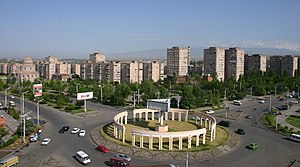
Malatia-Sebastia District
| Malatia-Sebastia Մալաթիա-Սեբաստիա |
|
|---|---|

Malatia-Sebastia district
|
|
 |
|
| Coordinates: 40°10′26.10″N 44°26′44.79″E / 40.1739167°N 44.4457750°ECoordinates: 40°10′26.10″N 44°26′44.79″E / 40.1739167°N 44.4457750°E | |
| Country | Armenia |
| Marz (Province) | Yerevan |
| Government | |
| • Mayor of District | Artak Aleksanyan |
| Area | |
| • Total | 26 km2 (10 sq mi) |
| Elevation | 950 m (3,120 ft) |
| Population (2011 census) | |
| • Total | 132,900 |
| • Density | 5,100/km2 (13,000/sq mi) |
| Time zone | (UTC+4) |
Malatia-Sebastia (Armenian: Մալաթիա-Սեբաստիա վարչական շրջան, Malatia-Sebastia varčakan šrĵan), is one of the 12 districts of Yerevan, the capital of Armenia, located in the western part of the city. As of the 2011 census, the district has a population of 132,900.
Malatia-Sebastia is bordered by the Ajapnyak District form the north, Kentron District from the east and Shengavit District from the south. It also has borders with the Armavir Province from the east and the Ararat Province from the southeast.
The name of the community is derived from two former major Armenian settlements in modern-day Turkey; Malatya and Sivas.
The district is unofficially divided into smaller neighborhoods such as: Nor Malatia, Zoravar Andranik, Shahumyan, Araratyan and Haghtanak.
In 1925, Western Armenian genocide survivors from the historic city of Malatya (nowadays in Turkey) founded the new settlement of Malatia to the west of Yerevan city centre. 2 years later, the settlement of Sebsatia was built at the north of Malatia, mainly by genocide survivors from the historic city of Sebastia. During the 1940s, with the expansion of the city of Yerevan, the settlements of Malatia and Sebastia along with the surrounding settlements became part of the capital city. In 1945, Malatia and Sebastia were connected to central Yerevan with the Victory Bridge and the Admiral Isakov Avenue.
In 1996, Malatia and Sebastia were merged into one district called Malatia-Sebastia, to become one of the 12 districts of Yerevan.
...
Wikipedia
