Makaweli
| Kaumakani, Hawaii | |
|---|---|
| Census-designated place | |

2004 aerial view of Kaumakani
|
|
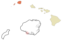
 Location in Kauai County and the state of Hawaii |
|
| Coordinates: 21°55′13″N 159°37′27″W / 21.92028°N 159.62417°WCoordinates: 21°55′13″N 159°37′27″W / 21.92028°N 159.62417°W | |
| Country | United States |
| State | Hawaii |
| County | Kauai |
| Area | |
| • Total | 1.0 sq mi (2.7 km2) |
| • Land | 1.0 sq mi (2.5 km2) |
| • Water | 0.1 sq mi (0.2 km2) |
| Elevation | 151 ft (46 m) |
| Population (2010) | |
| • Total | 749 |
| • Density | 635.7/sq mi (245.4/km2) |
| Time zone | Hawaii-Aleutian (UTC-10) |
| ZIP code | 96747 96769 |
| Area code(s) | 808 |
| FIPS code | 15-30650 |
| GNIS feature ID | 0360693 |
Kaumakani (literally, "place in the wind" in the Hawaiian language) is a census-designated place (CDP) in Kauaʻi County, Hawaiʻi, United States. The population was 749 at the 2010 census.
Kaumakani was officially known as Makaweli (which means "fearful features" in the Hawaiian language) for over forty years; Makaweli was an ancient land division (ahupuaʻa). In 1914, the Board on Geographic Names ruled that the community was to be named Makaweli, and only in 1956 did it name the CDP Kaumakani. Kaumakani has its own post office, with the ZIP code of 96747. In 2008, a small settlement to the west at 21°55′59″N 159°38′51″W / 21.93306°N 159.64750°W known as Pakala Village was designated its own CDP, and has its own post office with code 96769. Makaweli Landing at Pākala was called Robinson's Landing, since the family of Aubrey Robinson ran a private ferry to their island of Niʻihau.Pākala means "the sun shines" in Hawaiian.
...
Wikipedia
