Mahboobnagar
|
Mahabubnagar మహబూబ్ నగర్ محبوب نگر Palamoor |
|
|---|---|
| City | |

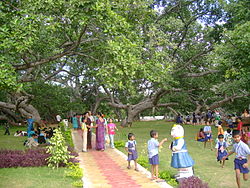
The biggest banayan tree (Pillalamarri), symbol of the district
|
|
| Coordinates: 16°45′N 78°00′E / 16.75°N 78.00°ECoordinates: 16°45′N 78°00′E / 16.75°N 78.00°E | |
| Country | India |
| State | Telangana |
| Region | Deccan |
| District | Mahbubnagar District |
| Founded by | Mahbub Ali Khan, Asaf Jah VI |
| Named for | Mahbub Ali Khan, Asaf Jah VI |
| Government | |
| • Body | Mahbubnagar Municipal Corporation |
| • Collector & District Magistrate | Dr. Ronold Ros IAS |
| • MLA | Srinivas Goud (TRS) |
| • MP | Jithender Reddy (TRS) |
| Elevation | 498 m (1,634 ft) |
| Population (2011) | |
| • Total | 217,942 |
| • Density | 167/km2 (430/sq mi) |
| Languages | |
| • Official | Telugu, Urdu |
| Time zone | IST (UTC+5:30) |
| PIN | 50900x |
| Telephone code | +91-08542 |
| Vehicle registration | TS-06 |
| Sex ratio | 0.973 ♂/♀ |
| Lok Sabha constituency | Mahbubnagar |
| Website | mahabubnagarmunicipality |
Mahabubnagar is a city in Mahabubnagar district of the Indian state of Telangana. It is the headquarters of Mahabubnagar mandal in Mahabubnagar revenue division. The city is also the largest in the district with an area of 98.64 km2 (38.09 sq mi) and 7th most populous in the state.
Mahabubnagar is also known with the name, Palamoor. The city also has an older name "Rukmammapet."
Mahabubnagar is located at 16°44′N 77°59′E / 16.73°N 77.98°E. It has an average elevation of 498 metres (1633 feet). The city of Mahabubnagar is located at a distance of 98 km from Hyderabad 108 km from Kurnool and 105 km from Raichur.
As of 2011[update]census, Mahabubnagar had a population of 217,942. The total population constitute, 110,955 males and 106,987 females—a sex ratio of 964 females per 1000 males.
Mahabubnagar municipality is the civic body of the city, which was constitured in 1942 as a third grade municipality. It was upgraded to second grade in 1959, to first grade in 1983 and finally to Special grade municipality in 2004. It is spread over an area of 98.64 km2 (38.09 sq mi). Mahbubnagar urban agglomeration consists of Mahbubnagar municipality, census towns of Boyapalle, Yenugonda and the out growths of Mahbubnagar (rural) (full), Yedira (part) village.
...
Wikipedia


