Magdalena River
| Magdalena | |
| River | |
|
The delta of the Magdalena River
|
|
| Name origin: Biblical figure Mary Magdalene | |
| Country | Colombia |
|---|---|
| Tributaries | |
| - left | Páez River, Saldaña River, La Miel River, Nare River, Cauca River, San Jorge River |
| - right | Cabrera River, Bogotá River, Negro River, Carare River, Sogamoso River, Cesar River |
| Cities | Neiva, Girardot, Honda, La Dorada, Puerto Boyacá, Puerto Berrío, Barrancabermeja, Santa Cruz de Mompox, Magangué, Barranquilla |
| Source | La Magdalena lagoon |
| - location | Colombian Massif, Colombia |
| - elevation | 3,685 m (12,090 ft) |
| - coordinates | 1°56′3″N 76°36′29″W / 1.93417°N 76.60806°W |
| Mouth | Caribbean Sea |
| - location | Baranquilla, Colombia |
| - elevation | 0 m (0 ft) |
| - coordinates | 11°7′0″N 74°51′0″W / 11.11667°N 74.85000°WCoordinates: 11°7′0″N 74°51′0″W / 11.11667°N 74.85000°W |
| Length | 1,528 km (949 mi) |
| Basin | 257,438 km2 (99,397 sq mi) |
| Discharge | for Calamar, Bolívar |
| - average | 7,200 m3/s (254,300 cu ft/s) |
| - max | 12,000 m3/s (423,800 cu ft/s) |
| - min | 2,000 m3/s (70,600 cu ft/s) |
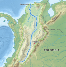
The Magdalena River (Spanish: Río Magdalena, Spanish pronunciation: [ˈri.o maɣðaˈlena]; Less commonly Rio Grande de la Magdalena) is the principal river of Colombia, flowing northward about 1,528 kilometres (949 mi) through the western half of the country. It takes its name from the biblical figure Mary Magdalene. It is navigable through much of its lower reaches, in spite of the shifting sand bars at the mouth of its delta, as far as Honda, at the downstream base of its rapids. It flows through the Magdalena River Valley.
Its drainage basin covers a surface of 27.3 million hectares (105,000 sq mi), which is 24% of the country's area and where 66% of its population lives.
The headwaters of the Magdalena River are in the south of Colombia, where the Andean subranges Cordillera Central and Cordillera Oriental separate, in Huila Department. The river then runs east of north in a great valley between the two cordilleras. It reaches the coastal plain at about nine degrees north, then runs west for about 100 km (62 mi), then north again, reaching the Caribbean Sea at the city of Barranquilla in the zone known as Bocas de Ceniza.
The Magdalena River basin, which includes the Cauca River and other tributaries, is very rich in fish. As of 2008[update], 213 fish species were known from the basin. Since then several new species have been described from the basin such as five Hemibrycon in 2013, two Ancistrus in 2013 and a Farlowella in 2014. Among the more famous species in the basin are Caquetaia umbrifera, Ctenolucius hujeta, Geophagus steindachneri, Ichthyoelephas longirostris, Panaque cochliodon, Pimelodus blochii, Potamotrygon magdalenae, Prochilodus magdalenae, Pseudoplatystoma magdaleniatum and Salminus affinis. About 55% of the fish species in the basin are endemic, including four endemic genera: The catfish Centrochir and Eremophilus, and the characids Carlastyanax (often included in Astyanax) and Genycharax. In general, the fish fauna shows connections with surrounding basins, notably Atrato and Maracaibo, but to a lesser extent also Amazon–Orinoco.
...
Wikipedia


