Madeira, Portugal
| Madeira | |||
| Autonomous Region (Região Autónoma) | |||
|
A January 2014 view of Funchal, the capital city of the autonomous region.
|
|||
|
|
|||
| Official name: Região Autónoma da Madeira | |||
| Name origin: madeira, Portuguese for wood | |||
|
Motto: Das Ilhas as Mais Belas e Livres (English: Of all islands, the most beautiful and free) |
|||
| Country | |||
|---|---|---|---|
| Autonomous Region | |||
| Region | Atlantic Ocean | ||
| Subregion | Tore-Madeira Ridge | ||
| Position | Madeira Platform, Savage Islands submarine mount |
||
| Islands | Madeira, Porto Santo, Desertas, Selvagens | ||
| Municipalities | Calheta, Câmara de Lobos, Funchal, Machico, Ponta do Sol, Porto Moniz, Porto Santo, Ribeira Brava, Santa Cruz, Santana, São Vicente | ||
| Capital | Funchal | ||
| Largest city | Funchal | ||
| - coordinates | 32°39′4″N 16°54′35″W / 32.65111°N 16.90972°WCoordinates: 32°39′4″N 16°54′35″W / 32.65111°N 16.90972°W | ||
| Highest point | Pico Ruivo | ||
| - location | Paul da Serra, Santana, Madeira | ||
| - elevation | 1,862 m (6,109 ft) | ||
| Lowest point | Sea level | ||
| - location | Atlantic Ocean, Madeira | ||
| - elevation | 0 m (0 ft) | ||
| Area | 801 km2 (309 sq mi) | ||
| Population | 289,000 (2016) Estimate |
||
| Density | 308.5/km2 (799/sq mi) | ||
| Settlement | c. 1420 | ||
| - Administrative autonomy | c. 1895 | ||
| - Political autonomy | 1 July 1976 | ||
| Discovery | c. 1415 | ||
| Management | |||
| - location | Assembleia Regional, Sé, Funchal | ||
| - elevation | 16 m (52 ft) | ||
| - coordinates | 32°38′49.96″N 16°54′29.59″W / 32.6472111°N 16.9082194°W | ||
| Government | |||
| - location | Quinta Vigia, Sé, Funchal | ||
| - elevation | 51 m (167 ft) | ||
| - coordinates | 32°38′42.39″N 16°54′57.16″W / 32.6451083°N 16.9158778°W | ||
| President (Government) | Miguel Albuquerque (PPD/PSD) | ||
| - President (Assembleia) | José Lino Tranquada Gomes (PPD/PSD) | ||
| Timezone | WET (UTC+0) | ||
| - summer (DST) | WEST (UTC+1) | ||
| ISO 3166-2 code | PT-30 | ||
| Postal code | 9XXX-XXX | ||
| Area code | (+351) 291 XXX XXX | ||
| ccTLD | .pt | ||
| Date format | dd-mm-yyyy | ||
| Drive | right-side | ||
| Demonym | Madeiran; Madeirense | ||
| Patron Saint | Nossa Senhora do Monte | ||
| Holiday | 1 July | ||
| Anthem |
A Portuguesa (national) Hino da Madeira (regional) |
||
| Currency | Euro (€) | ||
| GDP (nominal) | 2010 estimate | ||
| - Total | € 5.224 billion | ||
| - Per capita | € 21,100 | ||
|
Location of Madeira relative to Portugal (green) and the rest of the European Union (light green)
|
|||
|
Distribution of the islands of the archipelago (not including the Savage Islands)
|
|||
| Statistics: Instituto Nacional de Estatística | |||
| Website: www.gov-madeira.pt | |||
| Geographic detail from CAOP (2010) produced by Instituto Geográfico Português (IGP) | |||
| Madeira | |
| Island (Ilha) | |
|
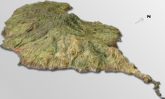
A three-dimensional rendering of topographic maps characterizing the island of Madeira
|
|
| Official name: Ilha da Madeira | |
| Name origin: madeira, Portuguese for the wood | |
|
Motto: Das ilhas, as mais belas e livres (Of all islands, the most beautiful and free) |
|
|
Nickname: Pérola do Atlântico (Pearl of the Atlantic) |
|
| Country | Portugal |
|---|---|
| Autonomous Region | Madeira |
| Location | Tore-Madeira Ridge, African Tectonic Plate, Atlantic Ocean |
| Municipalities | Calheta, Câmara de Lobos, Funchal, Machico, Ponta do Sol, Porto Moniz, Ribeira Brava, Santa Cruz, Santana, São Vicente |
| Highest point | Pico Ruivo |
| - location | Pico Ruivo, [(Santana)], Santana |
| - elevation | 1,862 m (6,109 ft) |
| Lowest point | Sea level |
| - location | Atlantic Ocean |
| - elevation | 0 m (0 ft) |
| Length | 57 km (35 mi), West-East |
| Width | 22 km (14 mi), North-South |
| Area | 740.7 km2 (286 sq mi) |
| Biomes | Temperate, Mediterranean |
| Geology | Alkali basalt, Tephra, Trachyte, Trachybasalt |
| Orogeny | Volcanism |
| Period | Miocene |
| Demonym | Madeirense; Madeiran |
| Ethnic groups | Portuguese |
| Website: www.gov-madeira.pt | |
| Statistics from INE (2001); geographic detail from Instituto Geográfico Português (2010) | |
Madeira (/məˈdɪərə/ mə-DEER-ə or /məˈdɛərə/ mə-DAIR-ə; Portuguese: [mɐˈðejɾɐ] or [mɐˈðɐjɾɐ]) is a Portuguese archipelago situated in the north Atlantic Ocean, southwest of Portugal. Its total population was estimated in 2011 at 267,785. The capital of Madeira is Funchal, located on the main island's south coast.
The archipelago is just under 400 kilometres (250 mi) north of Tenerife, Canary Islands. Since 1976, the archipelago has been one of the two Autonomous regions of Portugal (the other being the Azores, located to the northwest). It includes the islands of Madeira, Porto Santo, and the Desertas, administered together with the separate archipelago of the Savage Islands. The region has political and administrative autonomy through the Administrative Political Statue of the Autonomous Region of Madeira provided for in the Portuguese Constitution. The autonomous region is an integral part of the European Union, having pronounced status as an outermost region of the European Union, as detailed in Article 299-2 of the Treaty of the European Union.
...
Wikipedia


