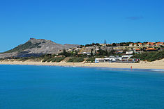
Porto Santo Island
| Porto Santo | |
| Island (Ilha) | |
|
Partial view of Porto Santo beach
|
|
| Official name: Ilha do Porto Santo | |
| Name origin: porto santo, Portuguese compound word for holy harbour | |
| Country | Portugal |
|---|---|
| Autonomous Region | Madeira |
| Location | Tore-Madeira Ridge, African Tectonic Plate, Atlantic Ocean |
| Municipalities | Porto Santo |
| Civil Parishes | Porto Santo |
| Highest point | Pico do Facho |
| - location | Northeastern Volcanic Complex |
| - elevation | 517 m (1,696 ft) |
| - coordinates | 33°5′4″N 16°19′20″W / 33.08444°N 16.32222°W |
| Lowest point | Sea level |
| - location | Atlantic Ocean |
| - elevation | 0 m (0 ft) |
| Length | 14.18 km (9 mi), Northwest-Southeast |
| Width | 7.77 km (5 mi), North-South |
| Area | 42.17 km2 (16 sq mi) |
| Population | 5,483 (2,011) |
| Biomes | Temperate, Mediterranean |
| Geology | Alkali basalt, Tephra, Trachyte, Trachybasalt |
| Orogeny | Volcanism |
| Period | Holocene, Pliocene |
| Demonym | Portossantense |
| Ethnic groups | Portuguese, Mulatto, Black |
|
Location of the island of Porto Santo in the Madeira archipelago
|
|
| Website: http://www.cm-portosanto.com | |
| Statistics from INE (2001); geographic detail from Instituto Geográfico Português (2010) | |
Porto Santo Island (Portuguese pronunciation: [ˈpoɾtu ˈsɐ̃tu]) is a Portuguese island 43 kilometres (27 mi) northeast of Madeira Island in the North Atlantic Ocean; it is the northernmost and easternmost island of the archipelago of Madeira, located in the Atlantic Ocean west of Europe and Africa.
It appears that some knowledge of Atlantic islands, such as Madeira, existed before the discovery and settlement of these lands, as the islands appear on maps as early as 1339. From a portolan dating to 1351, and preserved in Florence, Italy, it would appear that the islands of Madeira had been discovered long before being claimed by the Portuguese expedition of 1418. In Libro del Conocimiento (1348–1349), a Castilian monk also identified the location of the islands in their present location, with the names Leiname (modern Italian legname, cognate of Portuguese madeira, "wood"), Diserta and Puerto Santo. Indeed, the move by Portugal to claim the Madeiran islands was probably a response to Spain's efforts at the time to claim and subdue the Canary Islands.
However, humans never recorded the discovery of Porto Santo Island or the other Madeira islands until 1418, when Porto Santo was accidentally discovered after captains were storm blown into its sheltered harbor. They were in the service of Infante Henrique of Portugal. João Gonçalves Zarco and Tristão Vaz Teixeira had been ordered by King John I to discover new territory west of Africa and had been sent off-course by a storm while making the volta do mar westward swing return voyage. The island's name Porto Santo (en: "Holy Harbour") was derived from the sailors' stories of their discovery of a sheltered bay during the tempest, which was interpreted as divine deliverance. The first Portuguese settlers arrived in the 1420s.
...
Wikipedia


