Macleay Valley
| Macleay River | |
| Muddy River | |
| Open/trained mature wave dominated, barrier estuary | |
|
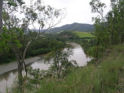
Macleay River, viewed at Lower Creek
|
|
| Name origin: In honour of Alexander Macleay | |
| Country | Australia |
|---|---|
| State | New South Wales |
| IBRA | New England Tablelands, NSW North Coast |
| Districts | Northern Tablelands, Mid North Coast |
| Local government area | Armidale Dumaresq, Bellingen, Kempsey |
| Tributaries | |
| - left | Chandler River, Top Creek, Dyke River, Sunday Creek (New South Wales), Georges Creek, Five Day Creek, Lagoon Creek, Nulla Nulla Creek, Hickeys Creek, Munga Creek, Christmas Creek |
| - right | Blue Mountain Creek, Apsley River, Kunderang Brook, Carrolls Creek, Felters Creek, Stockyard Creek, Mackenzies Creek, Warbro Brook, Parrabel Creek, Cadiangullong Creek, Dungay Creek |
| City | Kempsey |
| Primary source | Great Dividing Range |
| - location | Blue Nobby Mountain, near Uralla |
| - elevation | 455 m (1,493 ft) |
| Secondary source | Gara River |
| Source confluence | Salisbury Waters and Bakers Creek |
| Mouth | Tasman Sea, South Pacific Ocean |
| - location | near South West Rocks |
| - elevation | 0 m (0 ft) |
| Length | 298 km (185 mi) |
| Depth | 2.6 m (9 ft) |
| Volume | 70,235 m3 (2,480,326 cu ft) |
| Basin | 11,287 km2 (4,358 sq mi) |
| Area | 31.6 km2 (12 sq mi) |
| National Parks | Cunnawarra NP, Oxley Wild Rivers NP |
| Website: NSW Environment and Heritage webpage | |
Macleay River, an open and trained mature wave dominated, barrier estuary, is located in the Northern Tablelands and Mid North Coast districts of New South Wales, Australia.
Formed by the confluence of the Gara River, Salisbury Waters and Bakers Creek, the Macleay River rises below Blue Nobby Mountain, east of Uralla within the Great Dividing Range. The river flows in a meandering course generally east by south, joined by twenty-six tributaries including the Apsley, Chandler, and Dyke rivers and passing through a number of spectacular gorges and waterfalls in Cunnawarra National Park and Oxley Wild Rivers National Park, before reaching its mouth at the Tasman Sea of the South Pacific Ocean, near South West Rocks. The river descends 460 metres (1,510 ft) over its 298 kilometres (185 mi) course.
The river flows adjacent to the city of Kempsey. At Frederickton the river is traversed by the Pacific Highway via the Macleay River Bridge, the longest road bridge in Australia. The river is also traversed by the North Coast railway line.
...
Wikipedia

