Lurgan Township, Franklin County, Pennsylvania
| Lurgan Township, Franklin County, Pennsylvania |
|
|---|---|
| Township | |

|
|
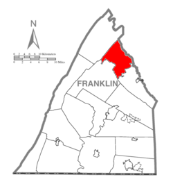
 Map of Franklin County, Pennsylvania highlighting Lurgan Township |
|
 Map of Franklin County, Pennsylvania |
|
| Country | United States |
| State | Pennsylvania |
| County | Franklin |
| Settled | 1736 |
| Incorporated | 1743 |
| Area | |
| • Total | 32.8 sq mi (85.0 km2) |
| • Land | 32.7 sq mi (84.7 km2) |
| • Water | 0.1 sq mi (0.3 km2) |
| Population (2010) | |
| • Total | 2,151 |
| • Density | 66/sq mi (25.4/km2) |
| Time zone | Eastern (EST) (UTC-5) |
| • Summer (DST) | EDT (UTC-4) |
| Area code(s) | 717 |
| Website | www |
Lurgan Township is a township in Franklin County, Pennsylvania, United States. The population was 2,151 at the 2010 census.
It was named after the town of Lurgan in Northern Ireland.
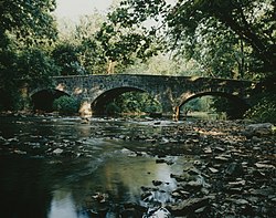
The McClay's Twin Bridge (East) and McClay's Twin Bridge (West) were listed on the National Register of Historic Places in 1988.
Lurgan Township is in northeastern Franklin County, bordered to the northeast by Cumberland County. The southeastern two-thirds of the township are in the Cumberland Valley, while the northwestern third is in the Ridge and Valley Province of the Appalachian Mountains. Conodoguinet Creek, a tributary of the Susquehanna River, forms the southern boundary of the township, while the northwestern boundary follows the crest of Kittatinny Mountain. Blue Mountain runs parallel to and east of Kittatinny Mountain through the township.
Interstate 76, the Pennsylvania Turnpike, crosses the northern part of the township, with access from Exit 201, the Blue Mountain Interchange. West of the interchange, the turnpike passes through the Blue Mountain Tunnel and Kittatinny Mountain Tunnel in rapid succession. The largest community in the township is Roxbury, in the southwest. Other unincorporated communities are McKinney, Otterbein, Mowersville, and Lurgan.
...
Wikipedia
