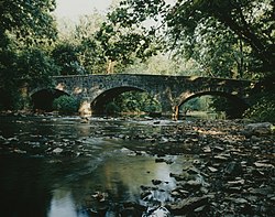
McClay's Twin Bridge (West)
|
Maclay's Twin Bridge (West)
|
|

Maclay's Twin Bridge (West), Summer 1997
|
|
| Location | Legislative Route 28010 over Conodoguinet Creek, near Middle Spring, Lurgan Township and Southampton Township, Pennsylvania |
|---|---|
| Coordinates | 40°5′49″N 77°34′15″W / 40.09694°N 77.57083°WCoordinates: 40°5′49″N 77°34′15″W / 40.09694°N 77.57083°W |
| Area | less than one acre |
| Built | 1827 |
| Built by | Harry, Silas |
| Architectural style | Other, Multi-span camelback arch |
| MPS | Highway Bridges Owned by the Commonwealth of Pennsylvania, Department of Transportation TR |
| NRHP Reference # | 88000779 |
| Added to NRHP | June 22, 1988 |
Maclay's Twin Bridge (West) is a historic multi-span stone arch bridge spanning a tributary of Conodoguinet Creek between Lurgan Township and Southampton Township in Franklin County, Pennsylvania. It is a 177-foot-long (54 m) bridge with three spans, the longest of which measures 31 feet (9.4 m) long. It was constructed in 1827 and is a twin of McClay's Twin Bridge (East).
The bridge was listed on the National Register of Historic Places in 1988.
...
Wikipedia


