Lubbock County, Texas
| Lubbock County, Texas | |
|---|---|

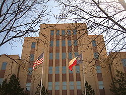
The current Lubbock County Courthouse
|
|
 Location in the U.S. state of Texas |
|
 Texas's location in the U.S. |
|
| Founded | 1891 |
| Named for | Thomas Saltus Lubbock |
| Seat | Lubbock |
| Largest city | Lubbock |
| Area | |
| • Total | 901 sq mi (2,334 km2) |
| • Land | 896 sq mi (2,321 km2) |
| • Water | 5.1 sq mi (13 km2), 0.6% |
| Population (est.) | |
| • (2015) | 299,453 |
| • Density | 332.36/sq mi (128/km²) |
| Congressional district | 19th |
| Time zone | Central: UTC-6/-5 |
| Website | www |
Lubbock County is a county located in the U.S. state of Texas. As of the 2010 census, the population was 278,831. Its county seat is Lubbock. The county was created in 1876 and organized in 1891. It is named for Thomas Saltus Lubbock, a Confederate colonel and Texas Ranger (some sources give his first name as Thompson).
Lubbock County, along with Crosby County, and Lynn County, is part of the Lubbock Metropolitan Statistical Area (MSA). The Lubbock MSA and Levelland Micropolitan Statistical Area (µSA), encompassing only Hockley County, form the larger Lubbock–Levelland Combined Statistical Area (CSA).
According to the U.S. Census Bureau, the county has a total area of 901 square miles (2,330 km2), of which 896 square miles (2,320 km2) is land and 5.1 square miles (13 km2) (0.6%) is water.
As of the census of 2000, there were 242,628 people, 92,516 households, and 60,135 families residing in the county. The population density was 270 people per square mile (104/km²). There were 100,595 housing units at an average density of 112 per square mile (43/km²). The racial makeup of the county was 74.30% White, 7.67% Black or African American, 0.59% Native American, 1.31% Asian, 0.04% Pacific Islander, 14.15% from other races, and 1.96% from two or more races. 27.45% of the population were Hispanic or Latino of any race.
...
Wikipedia
