Los Indios, Texas
| Los Indios, Texas | |
|---|---|
| Town | |
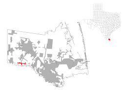
 Location of Los Indios, Texas |
|
 |
|
| Coordinates: 26°2′59″N 97°44′25″W / 26.04972°N 97.74028°WCoordinates: 26°2′59″N 97°44′25″W / 26.04972°N 97.74028°W | |
| Country | United States |
| State | Texas |
| County | Cameron |
| Area | |
| • Total | 1.7 sq mi (4.5 km2) |
| • Land | 1.7 sq mi (4.5 km2) |
| • Water | 0.0 sq mi (0.0 km2) |
| Elevation | 56 ft (17 m) |
| Population (2000) | |
| • Total | 1,149 |
| • Density | 668.0/sq mi (257.9/km2) |
| Time zone | Central (CST) (UTC-6) |
| • Summer (DST) | CDT (UTC-5) |
| ZIP code | 78567 |
| Area code(s) | 956 |
| FIPS code | 48-44128 |
| GNIS feature ID | 1374728 |
Los Indios is a bordertown in Cameron County, Texas, United States. The population was 1,083 at the 2010 census. It is included as part of the Brownsville–Harlingen–Raymondville and the Matamoros–Brownsville metropolitan areas. The Free Trade International Bridge connects Los Indios with Matamoros, Tamaulipas.
Los Indios had its start in the year 1913 by the building of the San Benito and Rio Grande Valley Railway through that territory.
Los Indios is located at 26°2′59″N 97°44′25″W / 26.04972°N 97.74028°W (26.049729, -97.740140).
According to the United States Census Bureau, the town has a total area of 1.7 square miles (4.4 km2), all of it land.
As of the census of 2000, there were 1,149 people, 273 households, and 245 families residing in the town. The population density was 668.0 people per square mile (257.9/km²). There were 310 housing units at an average density of 180.2 per square mile (69.6/km²). The racial makeup of the town was 53.79% White, 0.17% African American, 0.09% Native American, 43.95% from other races, and 2.00% from two or more races. Hispanic or Latino of any race were 95.82% of the population.
...
Wikipedia
