Loos-en-Gohelle
| Loos-en-Gohelle | |
|---|---|
 |
|
| Coordinates: 50°27′30″N 2°47′39″E / 50.4583°N 2.7942°ECoordinates: 50°27′30″N 2°47′39″E / 50.4583°N 2.7942°E | |
| Country | France |
| Region | Hauts-de-France |
| Department | Pas-de-Calais |
| Arrondissement | Lens |
| Canton | Wingles |
| Intercommunality | Communaupole de Lens-Liévin |
| Government | |
| • Mayor (2008–2020) | Jean-François Caron (Green) |
| Area1 | 12.7 km2 (4.9 sq mi) |
| Population (2010)2 | 6,778 |
| • Density | 530/km2 (1,400/sq mi) |
| Time zone | CET (UTC+1) |
| • Summer (DST) | CEST (UTC+2) |
| INSEE/Postal code | 62528 /62750 |
| Elevation | 31–74 m (102–243 ft) (avg. 44 m or 144 ft) |
|
1 French Land Register data, which excludes lakes, ponds, glaciers > 1 km² (0.386 sq mi or 247 acres) and river estuaries. 2Population without double counting: residents of multiple communes (e.g., students and military personnel) only counted once. |
|
1 French Land Register data, which excludes lakes, ponds, glaciers > 1 km² (0.386 sq mi or 247 acres) and river estuaries.
Loos-en-Gohelle is a commune in the Pas-de-Calais department in the Hauts-de-France region of France.
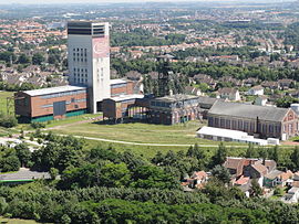
A former coal mining town, three miles northwest of the centre of Lens, at the junction of the D943 and the A21 autoroute. Its nearest neighbours are Lens to the south, Grenay to the west, Hulluch to the northeast and Bénifontaine to the east. The two largest (184 m & 182 m) spoil heaps in Europe are found here.
The place was first documented in 1071, as "Lohes". The name has changed considerably over the years: Lothae, Lo, Lohes, Loes, Loez and Loos. It was not until 1791 that the name of "Loos" was officially sanctioned. According to some, the name comes from the Germanic "Lôh" and Dutch "Loo" which mean "wood", but there is no archaeological evidence of what could have been a forest. According to others, the name derives from the Germanic "Laupo" which means marshy meadows, which, given the topography of the town, tends to support this theory. In 1937, after much confusion with Loos-lez-Lille (today Loos), it was decided to add the region’s name (Gohelle) to that of the commune.
The oldest documents that specify the existence of Loos date from the eleventh century, at the time of construction of the abbey of Anchin. But with the foundation of a church dedicated to Saint Vaast, it suggests that the village existed long before (St. Vaast lived in the 6th century).
By the Middle Ages, Loos-en-Gohelle was a large village whose inhabitants lived mainly by farming: in 1569, 350 inhabitants, in 1759, 600 people ; In 1824, 700 inhabitants and in 1850 around 800 people.
It was around 1850 that the town started to become prosperous; farmers could fertilize previously uncultivated land, thanks to technology provided by Guislain Decrombecque and the discovery of coal resulted in a very rapid increase of population. Many monuments and cemeteries reflect the destruction during World War I which completely destroyed the town, particularly during the Battle of Loos, from 25 September - 8 October 1915. At the end of the war, not a single building or tree had survived the pounding of artillery. Reminders of the war persist with the periodic discovery of unexploded ordnance.
...
Wikipedia


