Long Branch, Toronto
| Long Branch | |
|---|---|
| Neighbourhood | |

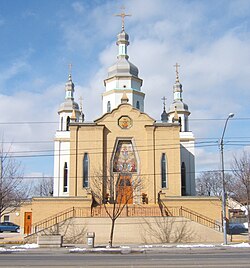
Ukrainian Orthodox Church on Lake Shore Blvd. West
|
|
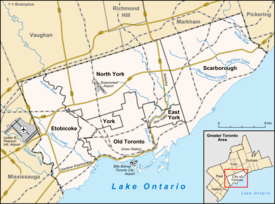
| Location within Toronto | |
| Coordinates: 43°35′29″N 79°31′57″W / 43.59139°N 79.53250°WCoordinates: 43°35′29″N 79°31′57″W / 43.59139°N 79.53250°W | |
| Country |
|
| Province |
|
| City |
|
| Community | Etobicoke |
| Established | 1884 planned (Subdivision) 'Sea Breeze Park' (1886, "Long Branch Park") 1891 (Postal village) |
| Incorporated | 1930 (Village) |
| Changed Municipality | 1953 1998 Toronto from Etobicoke |
| Annexed | 1967 into Etobicoke |
| Government | |
| • MP | James Maloney (Etobicoke—Lakeshore) |
| • MPP | Peter Milczyn (Etobicoke—Lakeshore) |
| • Councillor | Mark Grimes (Ward 6 Etobicoke—Lakeshore) |
Long Branch is a neighbourhood and former municipality in the south-west of Toronto, Ontario, Canada. It is located in the south-western corner of the former Township (and later, City) of Etobicoke on the shore of Lake Ontario. The Village of Long Branch was a partially independent municipality from 1930 to 1967. Long Branch is located within a land grant from the government to Colonel Samuel Smith in the late 18th Century. After Smith's death, a small portion of it was developed as a summer resort in the late 1800s.
Long Branch is primarily a residential district, composed mostly of single-family, detached homes. Along Lake Shore Boulevard West, numerous business are located in a low-rise commercial strip. South of Lake Shore Boulevard West, the area of single-family homes extends down to the lake. The area's lake shore is primarily privately owned, except for Long Branch Park and Marie Curtis Park.
Long Branch's population in 2011 was 9,625, a decline from 10,365 in 2001. The population has a higher proportion of working-age persons and lower proportions of children and seniors compared to the City of Toronto average. 65% of Long Branch persons indicate English as their mother tongue, with 31% having neither English or French to be the mother tongue of the household. The largest non-official language mother tongue is Polish at 6.3%, or 605 persons.
Long Branch is bounded by Lake Ontario on the south, with western boundaries of Etobicoke Creek north of Lake Shore Blvd. West and the western property line of the Canadian Arsenals Ltd. (Small Arms Ltd., WWII) (now within Marie Curtis Park) south of Lakeshore Road in Mississauga, Region of Peel. The northern boundary is the Canadian National Railway's mainline, with the eastern boundaries being Twenty-Third Street south of Lake Shore Blvd. West, and the midpoint between Twenty-Second and Twenty-Fourth Streets north of Lake Shore Blvd. West.
Before Long Branch became a village, it was the home to Loyalist Col. Sam Smith, who was one of the earliest settlers in Etobicoke. His cabin was located near Etobicoke Creek and survived into the 1950s. Col. Smith was granted a large tract of land for his service in the Queen's Rifles in 1797, which eventually extended from what is now Kipling Avenue to the original course of the Etobicoke River (now Creek), and south of Bloor Street to Lake Ontario after Col. Smith acquired additional parcels of land. The southern portion of this tract would include all of Long Branch and the westernmost portion of New Toronto, south of the railway line.
...
Wikipedia

