Lohnweiler
| Lohnweiler | ||
|---|---|---|
|
||
| Coordinates: 49°38′9″N 7°35′51″E / 49.63583°N 7.59750°ECoordinates: 49°38′9″N 7°35′51″E / 49.63583°N 7.59750°E | ||
| Country | Germany | |
| State | Rhineland-Palatinate | |
| District | Kusel | |
| Municipal assoc. | Lauterecken-Wolfstein | |
| Government | ||
| • Mayor | Walter Scherer | |
| Area | ||
| • Total | 4.91 km2 (1.90 sq mi) | |
| Elevation | 190 m (620 ft) | |
| Population (2015-12-31) | ||
| • Total | 400 | |
| • Density | 81/km2 (210/sq mi) | |
| Time zone | CET/CEST (UTC+1/+2) | |
| Postal codes | 67744 | |
| Dialling codes | 06382 | |
| Vehicle registration | KUS | |
| Website | vg-lauterecken.de | |
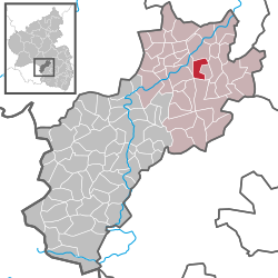
Lohnweiler is an Ortsgemeinde – a municipality belonging to a Verbandsgemeinde, a kind of collective municipality – in the Kusel district in Rhineland-Palatinate, Germany. It belongs to the Verbandsgemeinde Lauterecken-Wolfstein.
The municipality lies in the Lauter valley in the North Palatine Uplands. Lohnweiler lies at an elevation of roughly 165 m above sea level only about a kilometre south of the town of Lauterecken at the mouth of the Koppbach (or Mausbach), whose valley stretches off to the southwest. The elevations around the village reach heights of almost 340 m above sea level (Silberkopf 337 m, Dumpf 318 m, Leienberg 311 m). The municipal area measures 491 ha, of which roughly 20 ha is settled and 139 ha is wooded.
Lohnweiler borders in the north on the town of Lauterecken, in the northeast on the municipality of Hohenöllen, in the southeast on the municipality of Heinzenhausen, in the south on the town of Wolfstein, in the southwest on the municipality of Offenbach-Hundheim and in the west on the municipality of Wiesweiler. Lohnweiler also meets the municipality of Aschbach at a single point in the southwest.
The village core lies along with its church and former school on the left bank of the river Lauter’s (also called the Waldlauter, to distinguish it from other rivers in German-speaking Europe named ), in the outlet of the Mausbach valley, on both sides of a snaking road that bends to the south and continues as a country lane. From the village core, further streets with new building zones branch off to the north and south. East of this village core on the Lauter’s left bank runs the Lauter Valley Railway, and over on the right bank runs Bundesstraße 270 in a less heavily settled area. The graveyard lies south of the village core.
...
Wikipedia


