Offenbach-Hundheim
| Offenbach-Hundheim | ||
|---|---|---|
|
||
| Coordinates: 49°37′25″N 7°33′04″E / 49.62361°N 7.55111°ECoordinates: 49°37′25″N 7°33′04″E / 49.62361°N 7.55111°E | ||
| Country | Germany | |
| State | Rhineland-Palatinate | |
| District | Kusel | |
| Municipal assoc. | Lauterecken-Wolfstein | |
| Government | ||
| • Mayor | Jutta Lißmann | |
| Area | ||
| • Total | 7.91 km2 (3.05 sq mi) | |
| Elevation | 170 m (560 ft) | |
| Population (2015-12-31) | ||
| • Total | 1,089 | |
| • Density | 140/km2 (360/sq mi) | |
| Time zone | CET/CEST (UTC+1/+2) | |
| Postal codes | 67749 | |
| Dialling codes | 06382 | |
| Vehicle registration | KUS | |
| Website | www.offenbach-hundheim.de | |
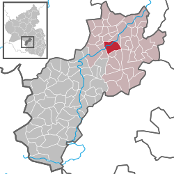
Offenbach-Hundheim is an Ortsgemeinde – a municipality belonging to a Verbandsgemeinde, a kind of collective municipality – in the Kusel district in Rhineland-Palatinate, Germany. It belongs to the Verbandsgemeinde Lauterecken-Wolfstein.
The municipality lies in the broad valley of the river Glan in the Western Palatinate. The municipal area measures 971 ha, of which 78 ha is settled (roughly 42 ha in Offenbach and roughly 36 ha in Hundheim) and 45 ha is wooded.
Within this merged municipality’s limits, the Ortsteil of Offenbach lies in the north on both sides of the Glan, although the village core nonetheless lies on the left bank. Here, the small stream known as the Gölschbach empties into the Glan. Within Offenbach, the Glan has a downstream drop of some 10 m from 174 m above sea level at the municipal limit with Glanbrücken to 164 m above sea level at the municipal limit with Wiesweiler. Above the village, the Kesselberg’s broad slope on the river’s left bank formed even after the Second World War an extensive vineyard area. There is now forest planted there. On the Glan’s right bank, the mountains reach heights of almost 300 m above sea level (Feistenberg, 292 m) and on the left bank almost 350 m above sea level (Trimschenberg, 344 m).
Within Offenbach-Hundheim’s limits, the Ortsteil of Hundheim lies south of the Glan in the valley of the Talbach, which here empties into the millrace feeding Offenbach’s Klostermühle (“Monastery Mill”). The Glan riverbed near the bridge between Offenbach and Hundheim has been measured at 171.3 m above sea level. The Talbach has a downstream drop of some 10 m from the municipal limit with Nerzweiler to its mouth. To the east, the mountains reach heights of almost 300 m above sea level at the Feistenberg (see above) and in the west almost 250 m above sea level at the Dumpf (244.9 m).
...
Wikipedia


