Lauterecken
| Lauterecken | ||
|---|---|---|
|
||
| Coordinates: 49°38′58″N 7°35′31″E / 49.64944°N 7.59194°ECoordinates: 49°38′58″N 7°35′31″E / 49.64944°N 7.59194°E | ||
| Country | Germany | |
| State | Rhineland-Palatinate | |
| District | Kusel | |
| Municipal assoc. | Lauterecken-Wolfstein | |
| Government | ||
| • Mayor | Heinrich Steinhauer | |
| Area | ||
| • Total | 8.91 km2 (3.44 sq mi) | |
| Elevation | 169 m (554 ft) | |
| Population (2015-12-31) | ||
| • Total | 2,133 | |
| • Density | 240/km2 (620/sq mi) | |
| Time zone | CET/CEST (UTC+1/+2) | |
| Postal codes | 67742 | |
| Dialling codes | 06382 | |
| Vehicle registration | KUS | |
| Website | www.lauterecken.de | |
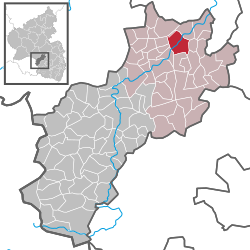
Lauterecken is a town in the Kusel district in Rhineland-Palatinate, Germany. It is the seat of the Verbandsgemeinde Lauterecken-Wolfstein, to which it also belongs. Lauterecken bears the nickname Veldenzstadt, after the comital family that once held sway here. It is also a state-recognized tourism resort town, and in terms of state planning is laid out as a lower centre.
The town lies in the North Palatine Uplands in a hollow at the mouth of the Lauter, where it empties into the Glan, and likewise at the mouth of the Grumbach, which also empties into the Glan. Lauterecken lies at an elevation of some 170 m above sea level. Elevations on each side of the dales mostly reach some 300 m above sea level, with the highest elevation being found at the peak known as die Platt (322 m above sea level). Lauterecken is found roughly 20 km northeast of Kusel, and 25 km northwest of Kaiserslautern. The municipal area measures 893 ha, of which 307 ha is wooded.
Lauterecken borders in the northeast on the municipality of Medard, in the east on the municipality of Cronenberg, in the southeast on the municipality of Hohenöllen, in the south on the municipality of Lohnweiler, in the southwest on the municipality of Wiesweiler, in the west on the municipalities of Hausweiler and Grumbach and in the northwest on the municipality of Kappeln and an exclave belonging to the municipality of Grumbach.
...
Wikipedia


