Grumbach
| Grumbach | ||
|---|---|---|
|
||
| Coordinates: 49°39′25″N 7°33′22″E / 49.65694°N 7.55611°ECoordinates: 49°39′25″N 7°33′22″E / 49.65694°N 7.55611°E | ||
| Country | Germany | |
| State | Rhineland-Palatinate | |
| District | Kusel | |
| Municipal assoc. | Lauterecken-Wolfstein | |
| Government | ||
| • Mayor | Werner Kreischer | |
| Area | ||
| • Total | 3.31 km2 (1.28 sq mi) | |
| Elevation | 240 m (790 ft) | |
| Population (2015-12-31) | ||
| • Total | 479 | |
| • Density | 140/km2 (370/sq mi) | |
| Time zone | CET/CEST (UTC+1/+2) | |
| Postal codes | 67745 | |
| Dialling codes | 06382 | |
| Vehicle registration | KUS | |
| Website | www.grumbach-glan.de | |
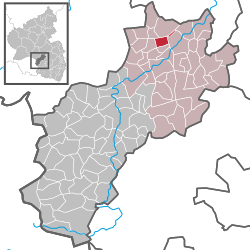
Grumbach is an Ortsgemeinde – a municipality belonging to a Verbandsgemeinde, a kind of collective municipality – in the Kusel district in Rhineland-Palatinate, Germany. It belongs to the Verbandsgemeinde of Lauterecken-Wolfstein.
The municipality lies in the Western Palatinate on the river Glan’s left bank, roughly 2 km up the Schwinzbach, which empties into the Glan at the biggest valley cut on the reach of the Glan between Niederalben and Meisenheim. Here, the valley broadens out, and the mountain spur being formed by the mouth of the Hundsgraben affords the site some solid ground. The settled centre is found exclusively on the south slope at an elevation of 235 m above sea level. The valley is bordered in the south by the 354 m-high so-called Hellenwald (forest) and in the north by the 338 m-high Roman road. The outlying centre of Windhof, lying 3 km to the northeast an elevation of 340 m above sea level offers the visitor an outstanding panorama of the surrounding countryside, owing to its exposed location. The municipal area measures 331 ha, of which 48 ha is wooded.
Grumbach borders in the north on the municipality of Kappeln, in the east on the town of Lauterecken, in the south on the municipality of Hausweiler, in the west on the municipality of Herren-Sulzbach and in the northwest on the municipality of Merzweiler. Grumbach also meets the municipality of Buborn at a single point in the southwest, and has an exclave to the northeast that borders in the northeast on the municipality of Medard, in the southeast and southwest on the town of Lauterecken and in the northwest on the municipality of Kappeln.
...
Wikipedia


