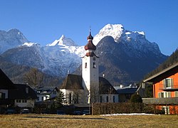
Lofer
| Lofer | ||
|---|---|---|

Parish church
|
||
|
||
| Location within Austria | ||
| Coordinates: 47°35′09″N 12°41′37″E / 47.58583°N 12.69361°ECoordinates: 47°35′09″N 12°41′37″E / 47.58583°N 12.69361°E | ||
| Country | Austria | |
| State | Salzburg | |
| District | Zell am See | |
| Government | ||
| • Mayor | Norbert Meindl (ÖVP) | |
| Area | ||
| • Total | 55.63 km2 (21.48 sq mi) | |
| Elevation | 626 m (2,054 ft) | |
| Population (1 January 2016) | ||
| • Total | 2,031 | |
| • Density | 37/km2 (95/sq mi) | |
| Time zone | CET (UTC+1) | |
| • Summer (DST) | CEST (UTC+2) | |
| Postal code | 5090 | |
| Area code | 06588 | |
| Vehicle registration | ZE | |
| Website | www.lofer.salzburg.at | |
Lofer is a market town in the district of Zell am See in the Austrian state of Salzburg.
Lofer is located in the historic Pinzgau region, in the valley of the Saalach river between the Chiemgau Alps and Reiter Alpe in the north and east, and the Lofer Mountains in the southwest. In the west, the road leads to the municipality of Waidring in Tyrol, while in the north the Kleines Deutsches Eck highway connection, part of the European route E641, runs along the Saalach river to the southwestern outskirts of Salzburg via neighbouring Unken and over the border with Germany.
The municipal area comprises the cadstral communities of Au, Hallenstein, Lofer, and Scheffsnoth.
Due to its location on the road to Tyrol, Lofer was an important post station. Its citizens were vested with market rights by the Prince-Bishops of Salzburg in 1473. The present-day parish church was erected around 1500.
The border with Tyrol at Strub Pass in the west was the site of several fortifications erected from the 13th century onwards. During the Napoleonic War of the Third Coalition in 1805, Austrian troops fought here against the French invaders. During the Tyrolean Rebellion four years later, Bavarian troops stormed the fortress, which soonafter was demolished.
...
Wikipedia


