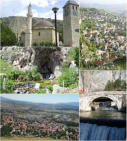
Livno
|
Livno Ливно |
|||
|---|---|---|---|
| Town and municipality | |||
 |
|||
|
|||
 Map of the Town of Livno |
|||
| Location of Livno in BiH | |||
| Coordinates: 43°49′31″N 17°00′21″E / 43.82528°N 17.00583°ECoordinates: 43°49′31″N 17°00′21″E / 43.82528°N 17.00583°E | |||
| Country | Bosnia and Herzegovina | ||
| Canton | Canton 10 | ||
| First mentioning | 28 September 892 CE | ||
| Government | |||
| • Mayor | Luka Čelan (HDZ BiH) | ||
| Area | |||
| • Municipality | 994 km2 (384 sq mi) | ||
| Elevation | 724 m (2,375 ft) | ||
| Population (2013) | |||
| • Total | 37,487 | ||
| • Density | 38/km2 (100/sq mi) | ||
| • Town | 9,045 | ||
| Time zone | CET (UTC+1) | ||
| • Summer (DST) | CEST (UTC+2) | ||
| Postal code | 80101 | ||
| Area code | 34 | ||
| Website | livno |
||
|
|
|
|
|
|
|
|
|
|
|
|
|
|---|---|---|---|---|---|---|---|---|---|---|---|
| 1879 | 1,425 | 31 | 2,394 | 52 | 778 | 17 | 0 | 0 | 4,597 |
|
1879 Glavni pregled političkoga razdielenja Bosne i Hercegovine |
| 1948 |
|
|
|
|
|
|
|
|
|
|
|
| 1953 |
|
|
|
|
|
|
|
|
|
|
|
| 1961 |
|
|
|
|
|
|
|
|
|
|
|
| 1971 |
|
|
|
|
|
|
|
|
|
|
|
| 1981 |
|
|
|
|
|
|
|
|
|
|
|
| 1991 |
|
|
|
|
|
|
|
|
|
|
|
| 2013 |
|
|
|
|
|
|
|
|
|
|
|
Livno (Serbo-Croatian pronunciation: [lǐːʋno]) is a town and municipality in the west of Bosnia and Herzegovina. It is part of Canton 10 of the Federation of Bosnia and Herzegovina. Situated on the river Bistrica in the southeastern edge of the Livno Field at the foot of Krug mountain and rocky hill Crvenice, it is the centre of the Canton 10 which mainly covers an area of the historical and geographical region of Tropolje.
The town, with the remains of the antique architecture and the old town from the 9th century, first mentioned in 892, developed at the crossroads of roads between the Adriatic coast and inland, i.e., regions of Bosnia, Dalmatia, Herzegovina and Krajina.
The plains of Livno have been populated since approximately 2000 BC. In the late Bronze Age, the Neolithic population was replaced by more Indo-European tribes known as the Illyrians. The region was inhabited by Illyrian tribe of Dalmatae which capital was Delminium in today's Tomislavgrad. They left remains that testify about their presence in this area. The most important of them are the gradine, remains of Illyrian settlements which were distributed along the Livno Field. The three most important are Velika gradina, Mala gradina and Kasalov gradac.
After the Roman conquest of the area, it was part of the province of Dalmatia. During the twenties of the first century AD, Roman government built a road connecting Salona, a city on the coast with Servitium, a city at the peripanonic lowlands. Its route passed through the Livno Field where two road stations have been established. The station of Pelva was located at the area of village Lištani and in the area of Livno station Bariduo was based.
...
Wikipedia


