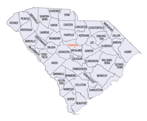
List of South Carolina counties
| Counties of South Carolina | |
|---|---|
 |
|
| Location | State of South Carolina |
| Number | 46 |
| Populations | 10,233 (McCormick) – 451,225 (Greenville) |
| Areas | 392 square miles (1,020 km2) (Calhoun) – 1,358 square miles (3,520 km2) (Charleston) |
| Government | County government |
| Subdivisions | cities, towns, unincorporated communities, census designated place |
The U.S. state of South Carolina is made up of 46 counties, the maximum allowable by state law. They range in size from 359 square miles (578 square kilometers) in the case of Calhoun County to 1,358 square miles (3,517 square kilometers) in the case of Charleston County. The least populous county is McCormick County, with only 9,958 residents, while the most populous county is Greenville County, with a population of 451,225, despite the state's most populous city, Columbia, being located in Richland County.
In the colonial period, the land around the coast was divided into parishes corresponding to the parishes of the Church of England. There were also several counties that had judicial and electoral functions. As people settled the backcountry, judicial districts and additional counties were formed. This structure continued and grew after the Revolutionary War. In 1800, all counties were renamed as districts. In 1868, the districts were converted back to counties. The South Carolina Department of Archives and History has maps that show the boundaries of counties, districts, and parishes starting in 1682.
Until the late 19th century, the Lowcountry of South Carolina was divided into Parishes which themselves subdivided several "districts"; these civil parishes were based on and generally coincident (even well after disestablishment) with Anglican ecclesiastical parishes.
...
Wikipedia
