Limpurg Hills
| Limpurg Hills | |
|---|---|

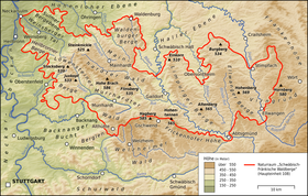
The Limpurg Hills in the central eastern part of the Swabian-Franconian Forest
|
|
| Highest point | |
| Peak | Altenberg |
| Elevation | 564.7 m above NHN |
| Geography | |
| Location | Counties of Schwäbisch Hall and Ostalbkreis, Baden-Württemberg, Germany |
| Range coordinates | 48°57′48″N 9°54′07″E / 48.963444°N 9.90194°ECoordinates: 48°57′48″N 9°54′07″E / 48.963444°N 9.90194°E |
The Limpurg Hills (German: Limpurger Berge) are a hill range, up to 564.7 m above sea level (NHN), in the Swabian-Franconian Forest in the counties of Schwäbisch Hall and Ostalbkreis in the German state of Baden-Württemberg. The majority of the region belonged formerly to Limpurg Land owned by the family of Schenken von Limpurg, whose name was derived from their family home, Limpurg Castle near Schwäbisch Hall.
The Limpurg Hills lie about 55 kilometres northeast of Stuttgart and around 60 kilometres (both as the crow flies) east-southeast of Heilbronn, between the Haller Ebene to the north, the Ellwangen Hills to the east and southeast, the Frickenhofer Höhe to the south, the Mainhardt Forest to the west and the Waldenburg Hills to the northwest. They lie southeast of Schwäbisch Hall, west of Sulzdorf, Obersontheim, Bühlertann, Bühlerzell and Adelmannsfelden and extend as far as the Blinde Rot river, northwest of Abtsgmünd. Untergröningen, Sulzbach-Laufen, Gaildorf, Westheim and Michelbach an der Bilz lie immediately west of the forested upland region.
...
Wikipedia
