Ellwangen Hills
| Ellwanger Berge | |
|---|---|

The Ellwangen Hills in the east of the
Swabian-Franconian Forest |
|
| Highest point | |
| Peak | Schönberg |
| Elevation | 569.2 m above NHN |
| Geography | |
| State | Counties of Schwäbisch Hall, Ostalbkreis in Baden-Württemberg, |
| Range coordinates | 48°58′03″N 10°01′58″E / 48.9674361°N 10.03278°ECoordinates: 48°58′03″N 10°01′58″E / 48.9674361°N 10.03278°E |
| Geology | |
| Type of rock | Keuper |
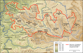
The Ellwangen Hills (German: Ellwanger Berge) are a hill ridge, up to 569.2 m above sea level (NHN), in the counties of Schwäbisch Hall and Ostalbkreis in the German state of Baden-Württemberg.
The name of the range comes from the town of Ellwangen. The hills are known nationally especially because of the eponymous motorway services on the A 7.
The Ellwangen Hills belong to the Keuper Uplands and lie about 65 kilometres northeast of the city of Stuttgart and around 67 kilometres (both as the crow flies) east-southeast of the city of Heilbronn between the Haller Plain to the north, the Franconian Heights and the Virngrund to the east, the Härtsfeld to the south, the Frickenhofer Höhe to the southwest and the Limpurg Hills to the west. They are situated south of Frankenhardt, west of Rosenberg and Ellwangen, northwest of Hüttlingen, east of Adelmannsfelden, Bühlerzell and Bühlertann and southeast of Obersontheim and Vellberg.
...
Wikipedia
