Waldenburg Hills
| Waldenburg Hills | |
|---|---|

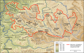
The Waldenburg Hills in the north of the Swabian-Franconian Forest Nature Park
|
|
| Highest point | |
| Peak | Mühlberg |
| Elevation | 522.8 m above NHN |
| Dimensions | |
| Length | 25.752 km (16.002 mi) |
| Geography | |
| State | Baden-Württemberg, Germany |
| Range coordinates | 49°10′01″N 9°40′15″E / 49.16694°N 9.67083°ECoordinates: 49°10′01″N 9°40′15″E / 49.16694°N 9.67083°E |
| Parent range | Swabian-Franconian Forest |
| Geology | |
| Orogeny | Mountain region |
The Waldenburg Hills (German: Waldenburger Berge) are a forested hill range, up to 522.8 m above sea level (NHN), in the counties of Schwäbisch Hall and Hohenlohe in the south German state of Baden-Württemberg.
At the same time the Waldenburg Hills are one of five woodland regions in the Swabian-Franconian Forest Nature Park, which forms the western part of the Swabian-Franconian Forest. Its name is derived from the town of Waldenburg on its northern perimeter.
The Waldenburg Hills lies in the northeastern part of the aforementioned nature park roughly about 50 km northeast of Stuttgart and about 30 km (both as the crow flies) east of Heilbronn between the Hohenlohe Plain to the north, the Halle Plain to the east, the Limpurg Hills to the southeast and the Mainhardt Forest to the south and southwest. According to the classification of the Handbook of the Natural Region Divisions of Germany by Meynen and Schmithüsen (1953–1962) they form natural region unit number 108.5 in the Swabian-Franconian Forest in the Swabian Keuper-Lias Land.
They are located immediately south of Waldenburg, not far and west of Schwäbisch Hall, north and northwest of Michelfeld, a few kilometres northeast of Mainhardt and roughly east of Pfedelbach.
...
Wikipedia
