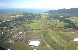
Lihue, Hawaii
| Lihue, Hawaii | |
|---|---|
| Census-designated place | |

Aerial view of Lihue
|
|
 Location in Kauai County and the state of Hawaii |
|
| Coordinates: 21°58′29″N 159°21′56″W / 21.97472°N 159.36556°WCoordinates: 21°58′29″N 159°21′56″W / 21.97472°N 159.36556°W | |
| Country | United States |
| State | Hawaii |
| County | Kauai |
| Area | |
| • Total | 7.1 sq mi (18.4 km2) |
| • Land | 6.3 sq mi (16.4 km2) |
| • Water | 0.8 sq mi (2.1 km2) |
| Elevation | 220 ft (67 m) |
| Population (2010) | |
| • Total | 6,455 |
| • Density | 898.3/sq mi (346.8/km2) |
| Time zone | Hawaii-Aleutian (UTC-10) |
| ZIP code | 96766 |
| Area code(s) | 808 |
| FIPS code | 15-45200 |
| GNIS feature ID | 0361837 |
Lihue or Līhuʻe is an unincorporated census-designated place (CDP) and the county seat of Kauai County, Hawaii. Lihue (pronounced [liːˈhuʔe]) is the second largest town on the Hawaiian island of Kauaʻi after Kapaʻa. As of the 2010 Census, the CDP had a total population of 6,455.
In ancient times, Lihue was a minor village. Līhuʻe means "cold chill" in the Hawaiian language. Lihue is located in the ancient district of Puna, the southeastern coast of the island, and land division (ahupuaʻa) of Kalapaki.Royal Governor Kaikioʻewa officially made it his governing seat in 1837, moving it from Waimea; he gave the town its name after the land he owned on Oahu by the same name.
With the emergence of the sugar industry in the 1800s, Lihue became the central city of the island with the construction of a large sugar mill. Early investors were Henry A. Peirce, Charles Reed Bishop and William Little Lee. The plantation struggled until William Harrison Rice built the first irrigation system in 1856.
...
Wikipedia
