Oahu
| Nickname: The Gathering Place | |
|---|---|

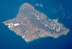
Satellite photo of Oʻahu
|
|
| Geography | |
| Location | 21°28′N 157°59′W / 21.467°N 157.983°WCoordinates: 21°28′N 157°59′W / 21.467°N 157.983°W |
| Area | 596.7 sq mi (1,545 km2) |
| Area rank | 3rd largest Hawaiian Island |
| Highest elevation | 4,003 ft (1,220.1 m) |
| Highest point | Kaʻala |
| Administration | |
|
United States
|
|
| Symbols | |
| Demographics | |
| Population | 953,207 (2010) |
| Pop. density | 1,636 /sq mi (631.7 /km2) |
Oʻahu (pronounced [oˈʔɐhu]) or Oahu /oʊˈɑːhuː/, known as "The Gathering Place", is the third largest of the Hawaiian Islands. It is home to about two-thirds of the population of the U.S. state of Hawaii. The state capital, Honolulu, is on Oʻahu's southeast coast. Including small close-in offshore islands such as Ford Island and the islands in Kāneʻohe Bay and off the eastern (windward) coast, it has a total land area of 596.7 square miles (1,545.4 km2), making it the 20th largest island in the United States. Along with the rest of the Hawaiian Islands, Oahu is one of the largest and northernmost islands of Polynesia.
In the greatest dimension, this volcanic island is 44 miles (71 km) long and 30 miles (48 km) across. The length of the shoreline is 227 miles (365 km). The island is the result of two separate shield volcanoes: the Waiʻanae and Koʻolau Ranges, with a broad "valley" or saddle (the central Oʻahu Plain) between them. The highest point is Kaʻala in the Waiʻanae Range, rising to 4,003 feet (1,220 m) above sea level.
The island was home to the Kunia Regional SIGINT Operations Center from 1941 to 2012; it is now home to the National Security Agency's Hawaii Cryptologic Center.
...
Wikipedia

