Lewis, Essex County, New York
| Lewis, New York | |
|---|---|
| Town | |
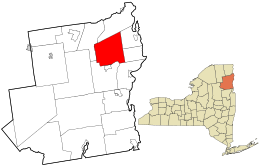
 Location in Essex County and the state of New York |
|
| Coordinates: 44°16′58″N 73°32′44″W / 44.28278°N 73.54556°W | |
| Country | United States |
| State | New York |
| County | Essex |
| Government | |
| • Type | Town Council |
| • Town Supervisor | David H. Blades (R) |
| • Town Council |
Members' List
|
| Area | |
| • Total | 85.0 sq mi (220.1 km2) |
| • Land | 84.8 sq mi (219.6 km2) |
| • Water | 0.2 sq mi (0.5 km2) |
| Elevation | 679 ft (207 m) |
| Population (2010) | |
| • Total | 1,382 |
| • Density | 16/sq mi (6.3/km2) |
| Time zone | Eastern (EST) (UTC-5) |
| • Summer (DST) | EDT (UTC-4) |
| ZIP code | 12950 |
| Area code(s) | 518 |
| FIPS code | 36-42114 |
| GNIS feature ID | 0979143 |
| Website | www |
Lewis is a town in Essex County, New York, United States. The population was 1,382 at the 2010 census. The town is named after Morgan Lewis, the governor of New York at the time the town was established.
The town is in the northeast quarter of the county. It is 30 miles (48 km) southwest of Burlington, Vermont, 32 miles (51 km) south of Plattsburgh, 94 miles (151 km) south of Montreal, Quebec, and 131 miles (211 km) north of Albany.
Settlement began before 1798 near Lewis village.
The town of Lewis was established in 1805 from a section of the town of Willsboro. Part of Lewis was taken in 1844 and 1854 to increase the size of the town of Elizabethtown.
Iron mining was an important early industry. Both Stowersville and Deerhead were communities based on the iron industry.
The First Congregational Church and Cemetery was listed on the National Register of Historic Places in 2005.
According to the United States Census Bureau, the town has a total area of 85.0 square miles (220.1 km2), of which 84.8 square miles (219.6 km2) is land and 0.2 square miles (0.5 km2), or 0.25%, is water. The town is drained by tributaries of the Boquet River, flowing east to Lake Champlain.
Lewis is inside the Adirondack Park.
...
Wikipedia
