Lesbos Island
|
Lesbos Περιφερειακή ενότητα / Δήμος Λέσβου |
|
|---|---|
| Regional unit | |

View of Mytilene
|
|
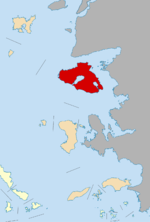
 Lesbos within the North Aegean |
|
| Coordinates: 39°10′N 26°20′E / 39.167°N 26.333°ECoordinates: 39°10′N 26°20′E / 39.167°N 26.333°E | |
| Country | Greece |
| Region | North Aegean |
| Capital | Mytilene |
| Area | |
| • Total | 1,632.8 km2 (630.4 sq mi) |
| Population (2011) | |
| • Total | 86,436 |
| • Density | 53/km2 (140/sq mi) |
| Demonym(s) | Lesbotian |
| Time zone | EET (UTC+2) |
| • Summer (DST) | EEST (UTC+3) |
| Postal codes | 81x xx |
| Area codes | 225x0 |
| Car plates | ΜΥ |
Lesbos (/ˈlɛzbɒs/, US /ˈlɛzboʊs/; Greek: Λέσβος Lesvos, pronounced [ˈle̞zvo̞s]), sometimes referred to as Mytilini after its capital, is a Greek island located in the northeastern Aegean Sea. It has an area of 1,632.819 square kilometres (630.435 sq mi) with 320 kilometres (199 miles) of coastline, making it the third largest island in Greece. It is separated from Turkey by the narrow Mytilini Strait and in late Palaeolithic/Mesolithic times was joined to the Anatolian mainland before the end of the last glacial period.
Lesbos is a separate regional unit of the North Aegean region, and is one of five governing islands within it. The others are Chios, Ikaria, Lemnos, and Samos. The total number of islands governed by the North Aegean are nine: Lesbos, Chios, Psara, Oinousses, Ikaria, Fournoi Korseon, Lemnos, Agios Efstratios and Samos. The capital of the North Aegean Region is Mytilene. The population of Lesbos is approximately 86,000, a third of whom live in its capital, Mytilene, in the southeastern part of the island. The remaining population is distributed in small towns and villages. The largest are Plomari, Kalloni, the Gera Villages, Agiassos, Eresos, and Molyvos (the ancient Mythimna).
...
Wikipedia
