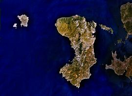
Chios
|
Chios Χίος |
|
|---|---|
 |
|
| Coordinates: 38°24′N 26°01′E / 38.400°N 26.017°ECoordinates: 38°24′N 26°01′E / 38.400°N 26.017°E | |
| Country | Greece |
| Administrative region | North Aegean |
| Regional unit | Chios |
| Area | |
| • Municipality | 842.3 km2 (325.2 sq mi) |
| Highest elevation | 1,297 m (4,255 ft) |
| Lowest elevation | 0 m (0 ft) |
| Population (2011) | |
| • Municipality | 51,930 |
| • Municipality density | 62/km2 (160/sq mi) |
| Time zone | EET (UTC+2) |
| • Summer (DST) | EEST (UTC+3) |
| Postal code | 82x xx |
| Area code(s) | 227x0 |
| Vehicle registration | ΧΙ |
| Website | www.chios.gr |
Chios (/ˈkaɪ.ɒs/; Greek: Χίος, alternative transliterations Khíos and Híos) is the fifth largest of the Greek islands, situated in the Aegean Sea, 7 kilometres (4.3 mi) off the Anatolian coast. The island is separated from Turkey by the Çeşme Strait. Chios is notable for its exports of mastic gum and its nickname is the Mastic Island. Tourist attractions include its medieval villages and the 11th-century monastery of Nea Moni, a UNESCO World Heritage Site.
Administratively, the island forms a separate municipality within the Chios regional unit, which is part of the North Aegean region. The principal town of the island and seat of the municipality is Chios town. Locals refer to Chios town as "Chora" ("Χώρα" literally means land or country, but usually refers to the capital or a settlement at the highest point of a Greek island).
Chios island is crescent or kidney shaped, 50 kilometres (31 mi) long from north to south, 29 kilometres (18 mi) at its widest, and covers an area of 842.289 square kilometres (325.21 sq mi). The terrain is mountainous and arid, with a ridge of mountains running the length of the island. The two largest of these mountains, "Pelineon" (1,297 metres (4,255 ft)) and "Epos" (1,188 metres (3,898 ft)), are situated in the north of the island. The center of the island is divided between east and west by a range of smaller peaks, known as "Provatas".
...
Wikipedia


