Lemington, VT
| Lemington, Vermont | |
|---|---|
| Town | |
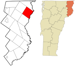
 Location in Essex County and the state of Vermont. |
|
 Location of Vermont in the United States |
|
| Coordinates: 44°55′26″N 71°33′25″W / 44.92389°N 71.55694°WCoordinates: 44°55′26″N 71°33′25″W / 44.92389°N 71.55694°W | |
| Country | United States |
| State | Vermont |
| County | Essex |
| Chartered | 1762 |
| Settled | 1789 |
| Organized | 1796 |
| Area | |
| • Total | 35.5 sq mi (92.0 km2) |
| • Land | 35.4 sq mi (91.6 km2) |
| • Water | 0.2 sq mi (0.4 km2) |
| Elevation | 2,070 ft (631 m) |
| Population (2010) | |
| • Total | 104 |
| • Density | 3/sq mi (1.1/km2) |
| Time zone | EST (UTC-5) |
| • Summer (DST) | EDT (UTC-4) |
| ZIP codes | 05903, 05905 |
| Area code(s) | 802 |
| FIPS code | 50-39700 |
| GNIS feature ID | 1462133 |
Lemington is a town in Essex County, Vermont, United States. The population was 104 as of the 2010 census. It is part of the Berlin, NH–VT Micropolitan Statistical Area.
Lemington is in northeastern Essex County along the Connecticut River, the border between Vermont and New Hampshire. The town is bordered to the southwest by Bloomfield, at its westernmost point by Lewis, to the northwest by Averill, and to the northeast by Canaan, all in Vermont. To the southeast, across the Connecticut, are the towns of Colebrook and Columbia, New Hampshire. Vermont Route 102 runs from south to north along the eastern edge of the town, following the Connecticut. Route 26 leads east across the Connecticut into Colebrook village. The villages of Lemington and Columbia are connected by the covered Columbia Bridge across the Connecticut.
According to the United States Census Bureau, the town of Lemington has a total area of 35.5 square miles (92.0 km2), of which 35.4 square miles (91.6 km2) is land and 0.2 square miles (0.4 km2), or 0.41%, is water. The town's highest point is 3,148-foot (960 m) Monadnock Mountain, in the eastern part of town overlooking the Connecticut.
...
Wikipedia
