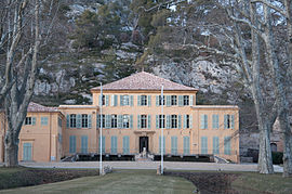
Le Tholonet
| Le Tholonet | ||
|---|---|---|

Société du Canal de Provence
|
||
|
||
| Coordinates: 43°31′22″N 5°30′42″E / 43.5228°N 5.5117°ECoordinates: 43°31′22″N 5°30′42″E / 43.5228°N 5.5117°E | ||
| Country | France | |
| Region | Provence-Alpes-Côte d'Azur | |
| Department | Bouches-du-Rhône | |
| Arrondissement | Aix-en-Provence | |
| Canton | Aix-en-Provence-Nord-Est | |
| Intercommunality | Pays d'Aix | |
| Government | ||
| • Mayor (2008–2014) | Michel Legier | |
| Area1 | 10.82 km2 (4.18 sq mi) | |
| Population (2008)2 | 2,227 | |
| • Density | 210/km2 (530/sq mi) | |
| Time zone | CET (UTC+1) | |
| • Summer (DST) | CEST (UTC+2) | |
| INSEE/Postal code | 13109 /13100 | |
| Elevation | 150–350 m (490–1,150 ft) (avg. 193 m or 633 ft) |
|
|
1 French Land Register data, which excludes lakes, ponds, glaciers > 1 km² (0.386 sq mi or 247 acres) and river estuaries. 2Population without double counting: residents of multiple communes (e.g., students and military personnel) only counted once. |
||
1 French Land Register data, which excludes lakes, ponds, glaciers > 1 km² (0.386 sq mi or 247 acres) and river estuaries.
Le Tholonet (Lou Toulounet and Lo Tolonet in Provençal) is a commune in the Bouches-du-Rhône department in southern France. Its inhabitants are called Tholonétiens.
The commune is near Aix-en-Provence, and at the foot of the montagne Sainte-Victoire. The river Arc goes through the commune.
The hamlet of Palette, which gives its name to the Palette AOC appellation, is located on the commune's territory.
The earliest signs of human presence can be dated back to the Iron Age, and are located in the Infernet and Espinades ranges.
In the nineteenth century, a small oppidum named "Ragabom camp" or "Ratabom camp" was discovered at the Infernet site. The camp consists of fortifications build with large stone blocks. The ruins are barely discernible today. Archeological surveys done from 1979-1980 helped discover furnishings dated from the Iron Ages up to the 2nd century BC, a time when the site was highly populated.
...
Wikipedia


