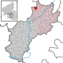
Langweiler, Kusel
| Langweiler | ||
|---|---|---|
|
||
| Coordinates: 49°39′56″N 7°31′31″E / 49.66556°N 7.52528°ECoordinates: 49°39′56″N 7°31′31″E / 49.66556°N 7.52528°E | ||
| Country | Germany | |
| State | Rhineland-Palatinate | |
| District | Kusel | |
| Municipal assoc. | Lauterecken-Wolfstein | |
| Government | ||
| • Mayor | Berthold Janß | |
| Area | ||
| • Total | 4.16 km2 (1.61 sq mi) | |
| Elevation | 288 m (945 ft) | |
| Population (2015-12-31) | ||
| • Total | 254 | |
| • Density | 61/km2 (160/sq mi) | |
| Time zone | CET/CEST (UTC+1/+2) | |
| Postal codes | 67746 | |
| Dialling codes | 06788 | |
| Vehicle registration | KUS | |
| Website | vg-lauterecken.de | |
Langweiler is an Ortsgemeinde – a municipality belonging to a Verbandsgemeinde, a kind of collective municipality – in the Kusel district in Rhineland-Palatinate, Germany. It belongs to the Verbandsgemeinde Lauterecken-Wolfstein.
The municipality lies on the Jeckenbach in the Western Palatinate between the Palatinate Forest and the Hunsrück. Langweiler lies at an elevation of some 250 to 300 m above sea level east of Bundesstraße 270 and mostly on the Jeckenbach’s right bank. Elevations around the village reach heights of almost 400 m to the west and some 370 m to the south and north. The municipal area measures 415 ha, of which roughly 11 ha is settled and 57 ha is wooded.
Langweiler borders in the north on the municipality of Sien, in the northeast on the municipality of Hoppstädten, in the east on the municipality of Merzweiler, in the south on the municipality of Homberg and in the west on the municipality of Unterjeckenbach. Langweiler also meets the municipality of Herren-Sulzbach at a single point in the southeast.
Langweiler’s houses stand mainly along two streets, one running east-west, and the other coming from the south and meeting the east-west street in the village centre. The village’s appearance is still widely characterized by Einfirstbauernhäuser (farmhouses with single roof ridges). The graveyard lies in the village’s south end on the road that leads to the neighbouring village of Homberg. East of the village, going towards Grumbach and Merzweiler, lies the sporting ground. The two buildings that once housed mills, the Ölmühle (oilmill) and the Tiefenbachermühle, still stand at the side of the road that leads to Unterjeckenbach. In the municipality’s south lie two further small settlements east of the Bundesstraße on the Kreisstraße to Homberg. The former schoolhouse today serves as a village community centre.
...
Wikipedia


