Landeshut
| Kamienna Góra | |||
|---|---|---|---|

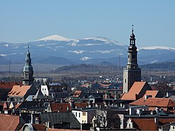
Kamienna Góra with Karkonosze mountain range
|
|||
|
|||
| Coordinates: 50°47′N 16°02′E / 50.783°N 16.033°E | |||
| Country |
|
||
| Voivodeship | Lower Silesian | ||
| County | Kamienna Góra | ||
| Gmina | Kamienna Góra (urban gmina) | ||
| Government | |||
| • Mayor | Krzysztof Świątek | ||
| Area | |||
| • Total | 17.97 km2 (6.94 sq mi) | ||
| Population (2006) | |||
| • Total | 21,440 | ||
| • Density | 1,200/km2 (3,100/sq mi) | ||
| Time zone | CET (UTC+1) | ||
| • Summer (DST) | CEST (UTC+2) | ||
| Postal code | 58-400 | ||
| Car plates | DKA | ||
| Website | http://www.kamiennagora.pl | ||
Kamienna Góra [kaˈmʲɛnːa ˈɡura] (German: Landeshut in Schlesien, Czech: Lanžhot, Kamenná Hora) is a town in south-western Poland with 21,440 inhabitants (2006). It is the seat of Kamienna Góra County, and also of the rural district called Gmina Kamienna Góra, although it is not part of the territory of the latter (the town forms a separate urban gmina).
Kamienna Góra on the Bóbr river is situated in Lower Silesian Voivodeship (from 1975–1998 it was in the former Jelenia Góra Voivodeship) between the Stone Mountains and the Rudawy Janowickie at the old trade route from Silesia to Prague, today part of the National Road No. 5. It lies approximately 95 kilometres (59 miles) south-west of the regional capital Wrocław.
In 1254 the Piast Duke Bolesław II the Bald of Legnica gave the area to the Benedictine monastery of Opatovice (in eastern Bohemia), who already had established Grüssau Abbey at nearby Krzeszów. When the abbey passed to the Cistercians in 1289, Kamienna Góra was acquired by Duke Bolko I the Strict of Świdnica, who extended it as a stronghold against Kingdom of Bohemia. It received town privileges by Duke Bolko II the Small in 1334. Nevertheless, the duchy fell to the Bohemian crown with Bolko's death in 1368. It burnt down during the 1426 Hussite campaign to Silesia.
...
Wikipedia


