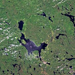
Lake Siljan
| Siljan | |
|---|---|

Landsat 7 satellite image
|
|
| Coordinates | 60°51′N 14°48′E / 60.850°N 14.800°ECoordinates: 60°51′N 14°48′E / 60.850°N 14.800°E |
| Basin countries | Sweden |
| Surface area | 354 km2 (137 sq mi) (including adjacent lakes) |
| Max. depth | 134 m (440 ft) |
| Water volume | 42 km3 (34×106 acre·ft) |
| Surface elevation | 161 m (528 ft) |
| Settlements | Mora |
Siljan, in Dalarna in central Sweden, is Sweden's sixth largest lake. The cumulative area of Siljan and the adjacent, smaller lakes Orsasjön and Insjön is 354 km2 (137 sq mi). Siljan reaches a maximum depth of 134 m (440 ft), and its surface is situated 161 m (528 ft) above sea level. The largest town on its shore is Mora.
The lake is located around the southwestern perimeter of the Siljan Ring (Swedish: Siljansringen), a circular geological formation which was formed 377 million years ago in the Devonian by a major meteorite impact. The original crater, now mostly eroded, is estimated to have been about 52 km (32 mi) in diameter and is the largest known impact crater in Europe (excluding Russia). The Cambrian, Ordovician and Silurian sedimentary rocks deformed by the impact are rich in fossils.
Some people suspect that there might be oil in the area, but drilling has been unsuccessful so far. There are large deposits of lead and zinc in the Boda area.
The government-owned power company Vattenfall drilled a deep well in search of natural gas. The project began as a deep commercial wildcat well, and its unusual location in fractured granite attracted scientific attention (e.g., as potentially significant in the context of theory of abiogenic petroleum origin).
The Gravberg-1 well location, in the north-northeast section of the ring, was chosen because a gravity anomaly indicates less dense rock below, and four seismic reflectors may represent cap rock above a natural gas reservoir. Electrical resistance is lower in the ring than outside it, suggesting the rocks contain fluid. Soil in the area showed clear traces of methane and heavy hydrocarbons, with a halo around the ring coincident with vanadium and nickel trace elements; the sediment was shown to not be the source of the hydrocarbons due to their location, ice movement pattern, and low level of maturity. Although the greatest gas leakage was in the north-northwestern corner, the lack of leakage in the central area suggested an underlying cap.
...
Wikipedia
