Laird, Ontario
| Laird | |
|---|---|
| Township (single-tier) | |
| Township of Laird | |

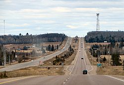
Highway 17 through Laird Township
|
|
| Coordinates: 46°23′N 84°04′W / 46.383°N 84.067°WCoordinates: 46°23′N 84°04′W / 46.383°N 84.067°W | |
| Country |
|
| Province |
|
| District | Algoma |
| Settled | 1874 |
| Incorporated | 1891 |
| Government | |
| • Mayor | Richard Beitz |
| • Federal riding | Sault Ste. Marie |
| • Prov. riding | Algoma—Manitoulin |
| Area | |
| • Land | 102.43 km2 (39.55 sq mi) |
| Population (2011) | |
| • Total | 1,057 |
| • Density | 10.3/km2 (27/sq mi) |
| Time zone | EST (UTC-5) |
| • Summer (DST) | EDT (UTC-4) |
| Postal Code | P0S |
| Area code(s) | 705 and 249 |
| Website | www.lairdtownship.ca |
Laird is a township and village in the Algoma District in Northern Ontario, Canada. The township had a population of 1,057 in the Canada 2011 Census, down from 1078 in the 2006 census.
The township includes the named communities of Laird and Neebish. It also includes a portion of Bar River, a small hamlet straddling the boundary between the townships of Laird and Macdonald, Meredith and Aberdeen Additional.
Population trend:
Highway 17 passes through the township. Tarbutt Township is a neighbour of Laird and is separated by a low-grade dirt road called "Townline Road" which spurs into a road to Pine Island.
...
Wikipedia

