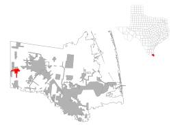
La Feria, TX
| La Feria, Texas | |
|---|---|
| City | |
| Motto: As Always | |
 Location of La Feria, Texas |
|
 Cameron County |
|
| Coordinates: 26°9′30″N 97°49′30″W / 26.15833°N 97.82500°WCoordinates: 26°9′30″N 97°49′30″W / 26.15833°N 97.82500°W | |
| Country | United States |
| State | Texas |
| County | Cameron |
| Area | |
| • Total | 5.5 sq mi (14.3 km2) |
| • Land | 5.4 sq mi (14.0 km2) |
| • Water | 0.08 sq mi (0.2 km2) |
| Elevation | 56 ft (17 m) |
| Population (2010) | |
| • Total | 7,302 |
| • Density | 1,347/sq mi (520.0/km2) |
| Time zone | Central (CST) (UTC-6) |
| • Summer (DST) | CDT (UTC-5) |
| ZIP code | 78559 |
| Area code(s) | 956 |
| FIPS code | 48-40204 |
| GNIS feature ID | 1339313 |
| Website | www |
La Feria is a city in Cameron County, Texas, United States. The population was 7,302 at the 2010 census. It is part of the Brownsville–Harlingen–Raymondville, the Matamoros–Brownsville and the McAllen–Edinburg–Mission metropolitan areas.
La Feria is located in western Cameron County at 26°9′30″N 97°49′30″W / 26.15833°N 97.82500°W (26.158253, -97.824973).
According to the United States Census Bureau, the city has a total area of 5.5 square miles (14.3 km2), of which 5.4 square miles (14.0 km2) is land and 0.1 square miles (0.2 km2), or 1.69%, is water.
In 2004, the city annexed the Arroyo Alto CDP, increasing the population of the city by roughly 300 people.
As of the census of 2000, there were 6,115 people, 2,021 households, and 1,620 families residing in the city. The population density was 3,075.1 people per square mile (1,186.4/km²). There were 2,895 housing units at an average density of 1,455.8 per square mile (561.7/km²). The racial makeup of the city was 74.91% White, 0.26% African American, 0.43% Native American, 0.33% Asian, 0.07% Pacific Islander, 20.69% from other races, and 3.32% from two or more races. Hispanic or Latino of any race were 77.45% of the population.
...
Wikipedia
