L'Anse aux Meadows
| L'Anse aux Meadows | |
|---|---|

|
|
| Coordinates | 51°35′42.96″N 55°31′52.4″W / 51.5952667°N 55.531222°WCoordinates: 51°35′42.96″N 55°31′52.4″W / 51.5952667°N 55.531222°W |
| Official name: L'Anse aux Meadows National Historic Site |
|
| Type | Cultural |
| Criteria | vi |
| Designated | 1978 (2nd session) |
| Reference no. | 4 |
| Country | Canada |
| Region | Europe and North America |
| Official name: L'Anse aux Meadows National Historical Site of Canada. | |
| Designated | 28 November 1968 |
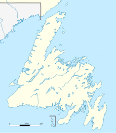
L'Anse aux Meadows (/ˈlænsi ˈmɛdoʊz/; from the French L'Anse-aux-Méduses or "Jellyfish Cove") is an archaeological site on the northernmost tip of the island of Newfoundland in the Canadian province of Newfoundland and Labrador. Discovered in 1960, it is the most famous site of a Norse or Viking settlement in North America.
Dating to around the year 1000, L'Anse aux Meadows is widely accepted as evidence of pre-Columbian trans-oceanic contact. It is notable for its possible connection with the attempted colony of Vinland established by Leif Erikson around the same period or, more broadly, with Norse exploration of the Americas. It was named a World Heritage site by UNESCO in 1978.
The site now known as L'Anse aux Meadows was first recorded as Anse à la Médée ("the Médée's Cove") on a French nautical chart made in 1862. The toponym probably referred to a ship named after the Greek mythological figure of Medea, which would have been a typical name for seagoing vessels at the time. The cove facing the modern village of L'Anse aux Meadows is still named Médée Bay.
...
Wikipedia

